


Instructions
Slope is the angle between the tangent plane of a certain point on the ground surface and the horizontal plane. The higher the slope value, the steeper the terrain. As shown in the following figure, set the angle value of the slope to θ:
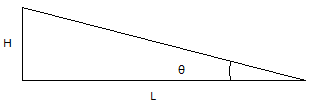
Among them, H is the vertical distance and L is the horizontal distance. Therefore, there is tan θ = H/L, and slope percentage=(H/L) * 100.
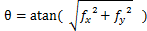
But for DEM grids, usually the cells to be calculated and their surrounding eight adjacent cells are used as calculation units, and the horizontal elevation change rate fx and vertical elevation change rate fy are used as calculation units To calculate the slope, i.e.:
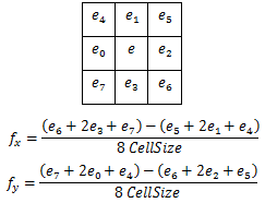
Among them, fx and fy are calculated using the third-order inverse distance squared difference method. The calculation formulas for fx and fy are as follows:
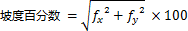
Slope can be expressed in angles, radians, or percentages. Taking the use of angles as an example, the range of slope calculation results is 0-90 degrees. There is a conversion relationship between radian and angle: radian=(angle/180)* Π; Here, it should be noted that the calculation formula for slope percentage is:
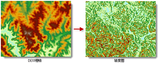
If the cell to be calculated has no value, the calculation result is also no value. It should be noted that for cells located at the edge of the raster dataset, their 3 × The 3 neighborhoods contain cells located outside the dataset range, for which the elevation values of the cells to be calculated will be used. Therefore, the resulting slope may be smaller than actual. For the absence of values in surrounding cells, the same method is also used. The newly generated slope dataset is a dataset of the same size and resolution as the original dataset. The following figure shows an example of calculating slope.
be careful: When calculating the slope, it is required that the unit of the grid value (i.e. elevation) to be calculated be the same as the unit of the x, y coordinates. If there is inconsistency, it can be adjusted through the elevation scaling coefficient (corresponding to the zFactor parameter in the method). However, it should be noted that when the conversion between elevation units and coordinate units cannot be adjusted through fixed values, the data needs to be processed through other means. One of the most common cases is that when the geographic coordinate system is used for DEM grid, the unit is degrees, and the elevation value is meters DEM grid is used for projection conversion, converting x and y coordinates into planar coordinates.
Setting the elevation scaling coefficient Zfactor
If the unit of measurement for z (elevation) is the same as x and y (horizontal) units, then the z factor is 1. If the measurement units are different, then a z-factor needs to be defined to explain this difference, as shown in the table below. For example, when using geographic coordinate system data (such as GCS_WGS 84 with longitude and latitude coordinate system), if the elevation is in meters, it is necessary to convert meters to degrees. Then set the conversion factor Zfactor to 0.00001, as shown in the following table.
| From | To | &# 160; | &# 160; |
| &# 160; | Feet | Meters | Degrees |
| Feet | 1 | 0.3048 | 0.000003 |
| Meters | 3.28084 | 1 | 0.00001 |
Parameter Specification
| Parameter Name | Default Value | Parameter Definition | Parameter Type |
|---|---|---|---|
| RDD to be analyzed | DEM RasterRDD to be analyzed | RasterRDD | |
| Elevation scaling factor (Optional) |
1.0 | Elevation scaling factor, which needs to be modified when using latitude and longitude data | Double |