


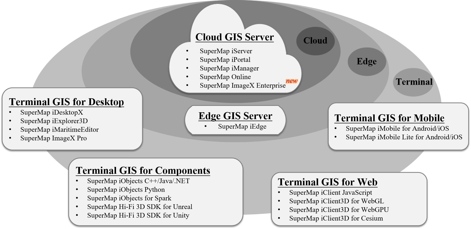
SuperMap GIS 2025 includes various software products such as cloud GIS servers, edge GIS servers, and client GIS, offering two delivery methods: offline deployment and online services (SuperMap Online).
Cloud GIS Servers
SuperMap iServer
SuperMap iServer is a server GIS software development platform based on a high-performance cross-platform GIS kernel, distributed and scalable, providing full-featured GIS service publishing, management, and aggregation capabilities, and supporting multi-level extension development.
The platform delivers robust web services related to spatial big data, GeoAI, and 3D, deeply integrating technologies like microservices, container orchestration, service mesh, and serverless computing, offering multiple SDKs to facilitate the construction of cloud-native GIS application systems with microservice architectures.
SuperMap iPortal
SuperMap iPortal is a GIS portal software platform that integrates GIS resource consolidation, search, sharing, and management, featuring capabilities such as zero-code rapid website building, multi-source data access, multi-source heterogeneous service registration, and multi-source service permission control.
The platform provides rich web applications for thematic map creation, spatial feature editing, distributed spatial analysis, 3D visualization, 3D modeling, automation of spatial data processing and analysis, and industry dashboard creation and display, supporting tasks like spatial data retrieval, analysis visualization, and portal management based on geospatial agent capabilities.
As the user center, resource center, and application center of the integrated cloud-edge-client GIS platform, it enables quick construction of GIS portal sites.
SuperMap iManager
SuperMap iManager is a comprehensive GIS operation and management software platform for application service management, infrastructure management, and big data management.
The platform offers a Kubernetes-based cloud-native GIS solution, enabling one-click creation and operation of cloud-native big data, AI, and 3D GIS systems, achieving fine-grained dynamic scaling and flexible deployment.
The platform monitors multiple GIS data storage, computing, and service nodes or other web sites, tracking metrics like hardware resource usage, map access hotspots, node health status, and service instance status, realizing integrated intelligent operation and management of GIS systems.
SuperMap Online
SuperMap Online GIS Platform (www.supermapol.com) integrates GIS data management, service management, data mining, and display, helping public cloud users securely migrate GIS data to the cloud, providing rich tools for online analysis and data presentation, creating a GIS resource creator platform from creation to revenue, and offering various SDKs for developers to access and utilize GIS data, facilitating rapid development of business systems.
SuperMap ImageX Enterprise
SuperMap ImageX Enterprise is a cross-platform integrated remote sensing and GIS server software. Leveraging a cloud-native architecture, it combines advanced photogrammetry and remote sensing core algorithms with technologies like intelligent and automated remote sensing imagery processing and high-performance computing. It supports distributed deployment and multi-node operation, enabling elastic and on-demand allocation of computing resources. It features "one high and five transformations" (distributed high-performance computing, integrated remote sensing and GIS, cross-platform software, intelligent processing and interpretation, cloud-native software architecture, and web-based interaction) and capabilities for automated production of massive optical remote sensing imagery DOM and integrated image intelligent interpretation, significantly improving remote sensing imagery processing efficiency and interpretation accuracy to achieve T+1 rapid application of remote sensing data products.
SuperMap AgentX Server (Beta)
SuperMap AgentX Server is SuperMap's AI large model-based geospatial agent service platform. Through conversational human-machine interaction, it provides comprehensive abilities for intent understanding, logical reasoning, task planning, and decision execution of complex GIS tasks. By leveraging the intent understanding and logical reasoning capabilities of various natural language large models, it constructs multiple agent forms such as knowledge Q&A (Chatflow Agent), workflow-based (Workflow Agent), and autonomous planning (Autonomous Agent). Using protocols like MCP for internal and external tool coordination, it delivers natural language interactive GIS solutions.
SuperMap AgentX Server is underpinned by foundational GIS software products like SuperMap iServer and SuperMap iPortal, which provide corresponding tool services, while the upper layer supports AI assistant products carried by WebGIS-class foundational software.
Edge GIS Servers
SuperMap iEdge
SuperMap iEdge is a GIS edge software platform deployed near clients or data sources, enabling local service publishing and real-time analysis processing to reduce response latency and bandwidth consumption, alleviating pressure on cloud GIS centers. It provides efficient service publishing capabilities and supports rapid release of massive vector data.
As an edge node between GIS clouds and application terminals, the platform enhances cloud GIS terminal access experience through service proxy aggregation and caching acceleration technologies, offering intelligent content distribution and efficient edge analysis processing to facilitate the construction of more efficient and intelligent integrated cloud-edge-client GIS application systems.
Component Client GIS
SuperMap iObjects Java
SuperMap iObjects Java is a large-scale fully component-based GIS software development platform, providing cross-platform and 2D-3D integrated capabilities, suitable for Java development environments.
SuperMap iObjects C++
SuperMap iObjects C++ is a large-scale fully component-based GIS software development platform, providing cross-platform and 2D-3D integrated capabilities, suitable for C++ development environments.
SuperMap iObjects .NET
SuperMap iObjects .NET is a large-scale fully component-based GIS software development platform, providing 2D-3D integrated capabilities, suitable for .NET development environments.
SuperMap iObjects Python
SuperMap iObjects Python is an out-of-the-box GIS scripting language package, providing capabilities for spatial data organization, conversion, cartography, processing and analysis, machine learning, etc., suitable for Python development environments.
SuperMap iObjects for Spark
SuperMap iObjects for Spark is a big data GIS software development component based on Apache Spark distributed technology, offering rich big data distributed management and analysis functions, suitable for Apache Spark distributed development environments.
SuperMap Hi-Fi 3D SDKs
SuperMap Hi-Fi 3D SDKs is a programmable, extensible, and customizable development platform based on next-generation 3D GIS technology deeply integrated with Unreal Engine 4/Unreal Engine 5 and Unity game engines. It supports local/online browsing of massive GIS spatial data, functions like measurement, clipping, 3D spatial analysis, and 3D spatial query, delivering high-fidelity 3D effects and novel application experiences to support rapid custom development of industry applications such as digital twins and smart cities.
Desktop Client GIS
SuperMap iDesktopX
SuperMap iDesktopX is a cross-platform 2D-3D integrated desktop GIS software platform, supporting mainstream operating systems like Linux and Windows, natively compatible with domestic software and hardware environments. It provides functions such as spatial data production and processing, distributed data management and analysis, cartography, data migration, GPA, machine learning, imagery, video mapping, and knowledge graph, usable for data production, processing, analysis, and business system customization.
SuperMap iExplorer3D
SuperMap iExplorer3D is a lightweight 3D scene browsing software, supporting rapid loading and smooth display of massive, multi-source, heterogeneous spatial data. By combining GIS software capabilities with game engine high-fidelity rendering, it enables users to quickly build high-fidelity 3D scenes.
SuperMap iMaritimeEditor
SuperMap iMaritimeEditor is a cross-platform electronic chart production desktop software, supporting mainstream operating systems like Linux and Windows. It enables data management, display, feature editing, sounding management, relationship management, and data inspection compliant with S-57, CJ-57, and IENC standards, meeting electronic chart production needs in domestic environments. It supports access to chart data conforming to S-101, S-102, S-104, S-127, and S-131 product specifications, and integrated data display and query across multiple standards.
SuperMap ImageX Pro
SuperMap ImageX Pro is a cross-platform remote sensing imagery desktop software for satellite remote sensing image data, integrating advanced photogrammetry core algorithms and built on technologies like automation, intelligence, and cross-platform compatibility. It features "one high and three transformations" (high-performance computing, integrated remote sensing and GIS, cross-platform software, and intelligent processing), providing capabilities for automated DOM and DSM/DEM data production and image quality inspection to achieve T+1 rapid application of remote sensing data products.
SuperMap TransformX
SuperMap TransformX is a cross-platform spatial data conversion software, fully adapted to domestic operating systems and hardware environments. It enables efficient batch conversion of 2D/3D spatial data and integrates data processing and analysis capabilities to meet spatial data conversion and processing demands across industries like natural resources, construction, transportation, and power.
Web Client GIS
SuperMap iClient JavaScript
SuperMap iClient JavaScript is a GIS web client development platform built on modern web technology stacks, serving as the unified JavaScript client for SuperMap GIS and online GIS platform series products.
SuperMap iClient3D for WebGL
SuperMap iClient3D for WebGL is a self-developed 3D GIS web client development platform based on WebGL technology, used to build plug-in-free, cross-operating-system, cross-device, cross-browser 3D GIS applications.
SuperMap iClient3D for WebGPU
SuperMap iClient3D for WebGPU is a self-developed 3D GIS web client development platform based on WebGPU technology, used to build plug-in-free, cross-operating-system, cross-device, cross-browser 3D GIS applications.
SuperMap iClient3D for WebGPU and SuperMap iClient3D for WebGL are the same product package, which simultaneously supports both WebGPU and WebGL rendering engines. Except for temporarily not supporting low-code development, other product features of SuperMap iClient3D for WebGPU are largely consistent with SuperMap iClient3D for WebGL.
SuperMap iClient3D for Cesium
SuperMap iClient3D for Cesium is a 3D GIS web client development platform implemented based on WebGL technology and the CesiumJS open-source framework, used to build plug-in-free, cross-operating-system, cross-device, cross-browser 3D GIS applications.
Mobile Client GIS
SuperMap iMobile for Android/iOS
SuperMap iMobile for Android/iOS is a mobile GIS development platform. Based on map browsing, data capture, data analysis, and route navigation, combined with AR mapping, emergency plotting, mobile 3D, and cloud collaboration, it is used to rapidly develop online, offline, 2D, and 3D mobile GIS applications, providing advanced, professional, and intelligent mobile GIS services for professional data capture product developers, industry mobile GIS product developers, and consumer-oriented mobile GIS product developers.
SuperMap iMobile Lite for Android/iOS
SuperMap iMobile Lite for Android/iOS is a lightweight mobile GIS development kit designed for online applications, providing open-source Android/iOS APIs. It features multi-source online basemap access, diverse map visualization effects, professional GIS data capture, and online analysis services.