


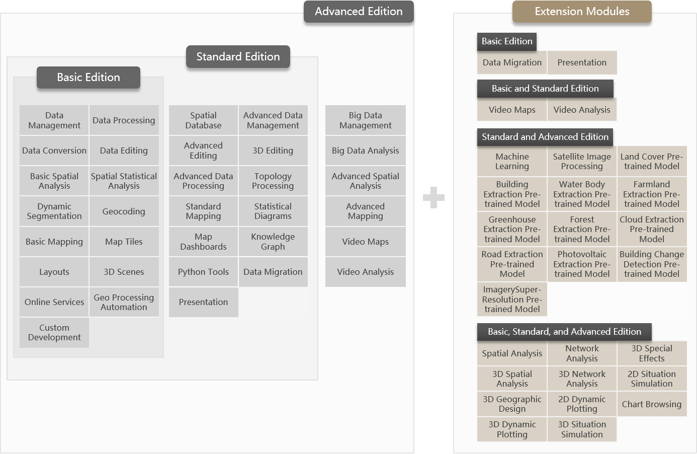
In order to meet the different needs of users, SuperMap iDesktopX provides three versions: Basic, Standard and Advanced. From the Basic Version to the Advanced Version, the product capabilities are enhanced in turn, and the latter version includes the functions of the former version. Meanwhile, extension modules are available for you to choose according to your needs.
- Basic Version
Provides basic data management, editing and processing tools; it provides the functions of data migration, statistical diagrams; supports integrated two and three dimensional display and interactive map production; supports two and three dimensional tile production and service release; supports basic spatial analysis and comprehensive spatial statistical analysis.
- Standard Version
On the basis of the Basic Version, the Standard Version enhances the functions of data management, editing, processing, map mapping, etc.; it provides the functions of 2D-3D integrated editing, topology processing, knowledge graph and map dashboards.
- Advanced Version
Based on the Standard Version, it provides comprehensive spatial analysis functions, as well as machine learning and big data management and analysis capabilities.
- Extension Modules
In the Basic, Standard, and Advanced Version, extended modules can be flexibly selected to enhance version capabilities and meet the diverse needs and budgets of users. Specifically:
-
The Standard Version already includes built-in Presentation module. This extension module does not need to be purchased separately after purchasing either the Standard or Advanced Version.
-
The Advanced Version includes built-in Spatial Analysis and Machine Learning modules, so users of the Advanced Version do not need to purchase these two modules separately.
-
The Satellite Imagery Processing, 3D Geological Modeling and 3D Flood Simulation Modules are only available as an optional module in the Standard Version and Advanced Version.
-
Pre-trained model extensions, including Land Cover, Building Extraction, Water Body Extraction, Farmland Extraction, Greenhouse Extraction, Forest Extraction, Cloud Extraction, Road Extraction, Photovoltaic Extraction, Building Change Detection, and ImagerySuper-Resolution, require a license for the Machine Learning module.
-
Supported Function Modules by Versions
|
|
|
|
|
|
|
|
|
|
|
|
|
|
|
|
|
|
|
|
|
|
|
|
|
|
|
|
|
|
|
|
|
|
|
|
|
|
|
|
|
|
|
|
|
|
|
|
|
|
|
|
|
|
|
|
|
|
|
|
|
|
|
|
|
|
|
|
|
|
|
|
|
|
|
|
|
|
|
|
|
|
|
|
|
|
|
|
|
|
|
|
|
|
|
|
|
|
|
|
|
|
|
|
|
|
|
|
|
|
|
|
|
|
|
|
|
|
|
|
|
|
|
|
|
|
|
|
|
|
|
|
|
|
|
|
|
|
|
|
|
|
|
|
|
|
|
|
|
|
|
|
|
|
|
|
|
|
|
|
|
|
|
|
|
|
|
|
| Presentation |
|
|
|
|
|
|
|
|
|
|
|
|
|
|
|
|
|
|
|
|
|
|
|
|
|
|
|
|
|
|
|
|
|
|
Supported Extension Modules by Version
|
|
|
Basic Edition | Standard Edition |
|
|
|
|
|
Optional | Optional |
|
|
|
|
|
Optional | Optional | Optional |
|
|
|
|
Optional | Optional |
|
|
|
|
|
Optional | Optional | Optional |
|
|
|
|
Optional | Optional | Optional |
|
|
|
|
|
Optional | Optional |
|
|
|
By combining 2D hydrodynamic models with 3D GIS visualization technology, achieves simulation analysis and dynamic display of flood processes:
|
|
Optional | Optional |
|
|
|
|
Optional | Built-in | Built-in |
|
|
|
|
Optional | Optional | Optional |
|
|
|
|
Optional | Optional | Optional |
|
|
|
|
Optional | Optional | Optional |
|
|
|
|
Optional | Optional | Optional |
|
|
|
|
|
Optional | Optional |
|
|
|
|
Optional | Optional | Optional |
|
| SuperMap iDesktopX TransformX Extension |
|
Optional | Optional | Optional |
|
|
|
|
Optional | Optional | Optional | This extension module can only be selected after the machine learning module is selected. |
|
|
|
Optional | Optional | Optional | |
|
|
|
Optional | Optional | Optional | |
|
|
|
Optional | Optional | Optional | |
|
|
|
Optional | Optional | Optional | |
|
|
|
Optional | Optional | Optional | |
|
|
|
Optional | Optional | Optional | |
|
|
|
Optional | Optional | Optional | |
| Photovoltaic Extraction Pre-trained Model |
|
Optional | Optional | Optional | |
| Building Change Detection Pre-trained Model |
|
Optional | Optional | Optional | |
| Image Super-resolution Pre-trained Model |
|
Optional | Optional | Optional |
Supported Functions by Operating System
SuperMap iDesktopX provides product packages for Windows (64-bit) and Linux systems, and the functions supported in different systems and architectures are different, as detailed in the following table:
|
|
|
|
|
|
|
|
|
|||
| Data Management | √ | √ | √ | |
| Data Processing | √ | √ | √ | |
| Data Conversion | √ | √ | √ | |
| Data Editing | √ | √ | √ | |
| Basic Mapping | √ | √ | √ | |
| Layouts | √ | √ | √ | |
| Map Tiles | Multi-tasking tile generation, tile checking, tile management | √ | √ | √ |
| 3D Scenes | Other Features | √ | √ | √ |
| Generate Tiles from Point Cloud | √ | × | × | |
| Basic Spatial Analysis | √ | √ | √ | |
| Spatial Statistical Analysis | √ | √ | √ | |
| Dynamic Segmentation | √ | √ | √ | |
| Geocoding | √ | √ | √ | |
| Online Services | √ | √ | √ | |
| Geo Processing Automation | √ | √ | √ | |
| Custom Development | √ | √ | √ | |
| Spatial Database | √ | √ | √ | |
| Advanced Data Management | √ | √ | √ | |
| Advanced Data Processing | √ | √ | √ | |
| Topology Processing | √ | √ | √ | |
| Advanced Editing | √ | √ | √ | |
| 3D Editing | √ | √ | √ | |
| Standard Mapping | Other Features | √ | √ | √ |
| AI illustrations | √ | √ | × | |
| Statistical Diagrams | √ | √ | √ | |
| Map Dashboards | √ | √ | √ | |
| Knowledge Graph | √ | √ | √ | |
| Python Tools | √ | √ | × | |
| Data Migration | √ | × | × | |
| Big Data Management | √ | √ | × | |
| Big Data Analysis | √ | √ | √ | |
| Spatial Analysis | √ | √ | √ | |
| Network Analysis | √ | √ | √ | |
| Machine Learning | Other Features | √ | √ | × |
| Video Maps | √ | × | × | |
| Video Analysis | √ | × | × | |
| 3D Spatial Analysis | √ | √ | √ | |
| 3D Special Effects | √ | √ | √ | |
| 3D Geographic Design | Other Features | √ | √ | √ |
| Import Model(SKP) | √ | × | × | |
| Import Model(FBX) | √ | √ | × | |
| 3D Geological Modeling | √ | × | × | |
| 3D Flood Simulation | √ | √ | √ | |
| 2D Dynamic Plotting | √ | √ | √ | |
| 2D Situation Simulation | √ | √ | √ | |
| 3D Dynamic Plotting | √ | √ | √ | |
| 3D Situation Simulation | √ | √ | √ | |
| Satellite Image Processing | √ | √ | √ | |
| Chart Browsing | √ | √ | √ | |
| SuperMap iDesktopX TransformX Extension | √ | √ | √ | |
| Land Cover Pre-trained Model | √ | √ | × | |
| Building Extraction Pre-trained Model | √ | √ | × | |
| Water Body Extraction Pre-trained Model | √ | √ | × | |
| Farmland Extraction Pre-trained Model | √ | √ | × | |
| Greenhouse Extraction Pre-trained Model | √ | √ | × | |
| Forest Extraction Pre-trained Model | √ | √ | × | |
| Cloud Extraction Pre-trained Model | √ | √ | × | |
| Road Extraction Pre-trained Model | √ | √ | × | |
| Photovoltaic Extraction Pre-trained Model | √ | √ | × | |
| BuildingChange Detection Pre-trained Model | √ | √ | × | |
| ImagerySuper-Resolution Pre-trained Model | √ | √ | × | |
|
|