Function Description
The Style Transfer function is a technology that transfers the image Style to the target image on the basis of retaining the content of the target image. At the same time, it supports adjusting the hue, brightness, contrast and saturation of filling, contour, line and label, so as to beautify the map as quickly as "PS".
Application Scenario
- It is applicable when the user has configured a map, but wants to change the display style to be applied to other scenes. For example, the user has a map with a bright color system, but needs to adapt to the map displayed on the large screen as a map with a dark color system, or needs to change the color matching style of the map to adapt to the style of a meeting place.
- It is suitable for personalized display of maps, such as ink painting style, ancient architecture style and so on.
Features
- Predefine multiple styles of pictures such as dark color system, color system, ink painting, etc., and support users to import Custom Picture.
- Style Transfer Settings: When reading the color of the picture, it supports setting the compression mode of the picture and reading the number of colors, so that the color matching can be finer and closer to the user's needs.
- Map Color Fixer: Support the adjustment of hue, brightness, contrast, saturation, Soften/Sharpen and other colors of the rendered text, line and surface layers, so as to achieve a more ideal picture effect. It also supports the adjustment of color, grayscale, black and white, and reverse color.
- Undo/Redo: Support the undo and rollback of Map Migration operation through the " Undo"/ " Redo" button, and support the undo and rollback operation through the shortcut key Ctrl + Z/Ctrl + Y.
Style Transfer Operation Instruction
Users can migrate by selecting the template picture provided by the program. At present, multiple sets of style pictures such as dark color system, color system and ink painting are predefined. At the same time, users can import Custom Picture.
- Open the configured map in Map.
- Use Template Picture: In the Gallery control of the AI Mapping tab-> Style Transfer group, click any picture to render the map based on the current picture. The map after Style Transfer is displayed in the Map.
- Use Custom Picture: In the Gallery control of the AI Mapping tab-& gt Style Transfer group-& gt Click the "Custom" button and upload the Custom Picture to render the Current Map based on the Select Picture. The Map after Style Transfer is displayed in the Map. A picture preview dialog box pops up
- in the lower left corner of Map, and you can click the Select button to change the Custom Picture; If the preview window is closed, select the " Display Preview Window" check box on the Style Transfer Settings dialog to open the picture preview window.
Style Transfer Settings
Before specifying Picture Style, it is supported to set the compression mode and the number of colors of the picture when Pick Color, so as to improve the processing performance of the picture.
- On the AI Mapping tab-> Gallery controls in the Style Transfer group, click the Transfer Settings "button to bring up the Style Transfer Settings" dialog.
- Compression mode: 4 compression modes for pictures are provided to improve the picture reading speed and the Picture processing performance. For a Detail Description of the interpolation, see: Introduction to the Grid Resampling Method .
- None: The image is not compressed, and the original aspect ratio of the picture is used.
- Anti-aliasing: The anti-aliasing algorithm based on sampling can well deal with the problems of rendering distortion and aliasing at the edge of the image. The processed image has the highest quality (with the least loss), but it consumes less resources and has lower performance compared with other modes.
- Nearest Neighbor Interpolation: Based on the K-nearest neighbor algorithm, the pixel value of each point in the target image is set as the nearest point in the source image. It has the advantages of simple processing, fast speed and fast performance, but the quality of the processed image is lower than that of other modes.
- Linear interpolation: The image is resampled using simple Linear interpolation. The output quality is lower than Cubic spline interpolaion, but the performance is better.
- Cubic spline interpolaion: The algorithm uses cubic interpolation to resample the image. Output quality is lower than antialiasing, but performance is higher than antialiasing.
- Number of colors: Support the setting of the number of colors to be extracted from the image. The Default Color range of the program is 50 ~ 200. The user can specify a reasonable number of colors according to the Current Map.
Map Color Fixer
Support the adjustment of hue, brightness, contrast, saturation, Soften and Sharpen, and adjust the color of the rendered text, line and surface layers to achieve a more ideal picture effect. At the same time, it supports color, grayscale, black and white, reverse color and other operations for Map color fixer.
- Click any button of " Hue", " Brightness", " Contrast", " Saturation" and " Soften/Sharpen" in the AI Matching tab-> Map Color Fixer group, and the Map Color Fixer panel will pop up. Current Map Brightness, Contrast, Saturation and Hue can be adjusted via sliders and by entering precise values, effective for All Layers:
- To adjust the fill, contour, line and Label Layer in the map separately, click the + button on the right side of the input value box to pop up the classification Map Color Fixer panel. Adjust the hue, brightness, contrast, and saturation of the fill, outline, line, and Label Layer.
- Hue: Adjust the hue of Current Map color; hue is the primary feature of color, and any color other than black, white and gray has hue.
- Brightness: Adjust the brightness of the Current Map color.
- Contrast: Adjust the contrast of the Current Map color.
- Saturation: Adjust the saturation of the Current Map color, which is the purity of the color. The higher the purity, the brighter the performance. The lower the purity, the darker the performance.
- Soften/Sharpen: Adjust the value of Sharpen to sharpen or feather the map. A positive value is sharpening, and a negative value is softening. Increasing sharpening decreases softness, and vice versa.
- Color: Change gray style map to color style.
- Gray: Change the map style to gray.
- Black and white: Change the map to black and white style.
- Invert: Invert the color of the map.
Parameter Description:
Application example
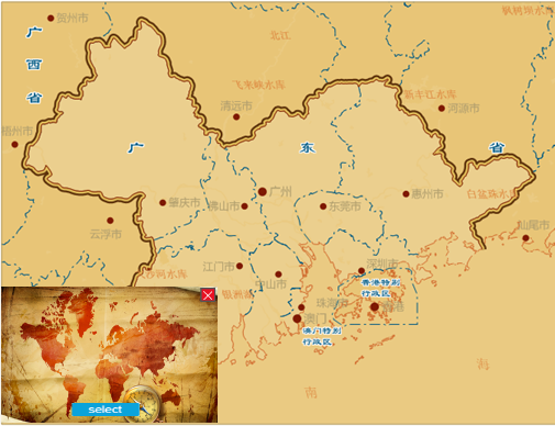
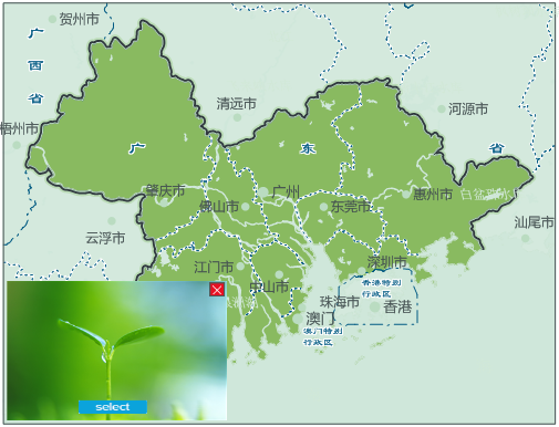
There is a map of the administrative region of the Pearl River Delta. The government divides it into two topics when publicizing it: the historical development of the Pearl River Delta and the regional environmental protection. In order to adapt to the two different themes, the map style can be adapted to the corresponding theme by selecting two different picture styles of ancient map and green vegetation, and the results shown in the following figure are obtained:
 |
 |
| Historical style map | Eco-style map |


