


2. 3D Data integration refers to the integrated storage and management of 2D and 3D Spatial Data. 2D and 3D Data are integrated in data model and data structure. 3D GIS data is not only compatible with 2D data structure, but also adjusted appropriately, which realizes that all 2D data can be visualized directly in 3D Scene with high performance without any conversion processing.
SuperMap 3D GIS is based on the OGDC standard (Open Geo-DataBase Connectivity, Open Spatial DataBase Connectivity Standard), which enables undifferentiated access to multiple data sources and loads different formats of data from different platforms into the same scene for display. 3D Scene supports various types of data as follows:
- Support 3D display of 2D data, that is, add various 2D Geometry or 2D Vector Layer to 3D Scene;
- Support 3D processing of 2D data, such as stretching 2D objects into 3D faces and 3D bodies, and 3D rendering of stretched objects such as 3D Texture Map;
- Support importing or adding 3D Dataset, 3D Geometry and Model to 3D Scene;
- Support loading Image Data and Terrain Data into 3D Scene;
- Support the loading of data such as Map Cache, Vector Cache, Imagery Cache and Model Cache into the scene;
- Support for adding KML files to 3D Scene as 3D layers;
- Support loading Screen Mapping into the scene, and so on.
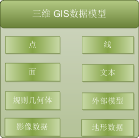 |
| Figure 1: Supported 3D Data Models |
The 3D Data in the 3D Scene is organized as a 3D layer, that is, adding 3D Data to the 3D Scene is actually adding Data to the corresponding type of layer in the 3D Scene. The 3D layers in the 3D Scene can be divided into Normal Layer, Screen Layer, Terrain Layer, and 3D Tracing Layer, wherein the 3D Scene can contain multiple types of layers, and these layers are managed by a 3D layer set. There can also be more than one Terrain Layer, which is managed by the Terrain Layer collection accordingly, while only one Screen Layer and 3D Tracing Layer are included in the 3D Scene.
Note: There are five common 3D layers: 3D Dataset Layer, 3D Map Layer, KML Layer, Image Files Layer and Model Cache Layer.
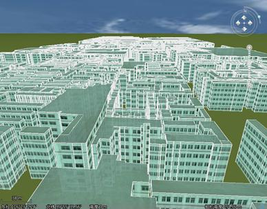 |
| Figure 2: Region Dataset added to 3D Scene (stretched and mapped) |