


There are 11 kinds of national Basic Scale topographic maps in China, including:
1:1,000,000、1:500,000、1:250,000、1:100,000、1:50,000、1:25,000、1:10,000、1:5000、1:2000、1:1000、1:500 。
Ordinary maps are usually divided into large, medium and small scales: less than 1 million (small scale), 100,000 to 1 million (medium scale), and more than 100,000 (large scale).
At present, China's 1:1000000, 1:500000, 1:250000 and 1:100000 topographic maps have covered all the land territory; 1:50000 and 1:10000 topographic maps have covered about 85% and 47% of the land territory respectively; 1:5000 and 1:2000 or larger scale topographic maps have basically covered all urban areas.
1: 1,000,000 Topographic Map |
|||
 |
The 1: 1,000,000 topographic map comprehensively reflects the general situation of physical geography and social economy within the scope of mapping. It is used for macro-evaluation and research of geographic information in a wide range. It is the platform of basic geographic information and topographic elements commonly needed by various departments of the country. It can be used as the overall planning of economic construction for various departments. Maps or working base maps for planning and management of economic layout, production layout and development and utilization of land and resources can also be used as maps for national defense construction, as well as basic data for smaller scale ordinary maps and geographical base maps for thematic maps. The1: 1,000,000 topographic map is mapped by the method of normal isometric conic projection. The international 1: 1,000,000 map division standard is adopted for division and numbering. Starting from the equator, every 4 ° of latitude is a column, and the Latin letters A, B, C, etc. Are used in turn. V means (Arabic numerals 1, 2, 3 were once used in the 1970s.. The column number is preceded by N or S to distinguish the northern hemisphere from the southern hemisphere (China is located in the northern hemisphere, and the N in front of the figure number is omitted); counting from the 180 ° meridian, 6 ° from west to east is a vertical line, and the whole world is divided into 60 vertical lines, with 1, 2, 3.. 60 indicates that the combination of "column number-row number" is the number of the figure. For example: J-50, 10-50. |
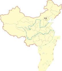
||
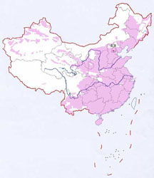
| 1: 1,000,000 topographic map coverage map | |||
1: 500,000 topographic map |
|||
 |
The 1: 500,000 topographic map comprehensively reflects the general situation of physical geography and social economy within the mapping scope. It is used for macro-evaluation and research of geographic information in a larger scope. It is the platform of basic geographic information and topographic elements commonly needed by various departments of the country. It can be used as the overall planning of economic construction for various departments. Provincial economic layout, production layout, land and resources development and utilization planning and management maps or working base maps can also be used as national defense construction maps, as well as basic data for smaller scale ordinary maps and geographic base maps for thematic maps. The1: 500,000 topographic map adopts Gauss-Kruger projection, 6 ° zoning, and is mapped by the compilation method. The division and numbering are based on the 1: 1,000,000 topographic map. Each 1: 1,000,000 topographic map is divided into two rows and two columns, totaling four 1: 500,000 topographic maps. Before the 1970s, they were represented by A,, В or A, B, C and D. Since the 1970s, they have been represented by Latin letters A, B, C and D. Add the code of 1: 500,000 topographic map after the number of 1: 1,000,000 topographic map, which is the number of 1: 500,000 topographic map, such as J — 50 — Γ, 10 — 50 — D, J — 50 — D. Since the 1990s, the Planar Coordinate System has adopted the 1980 Xi'an Coordinate System and the Elevation System has adopted the 1985 National Elevation Datum; The sheet division and numbering are based on the sheet division and numbering of 1: 1,000,000 map, and the new sheet division standard is divided. The code and row number of 1: 500,000 are added after the sheet number of 1: 1,000,000 map, such as J47B001002. A 1: 500,000 topographic map has a range of 3 ° of longitude and 2 ° of latitude. |
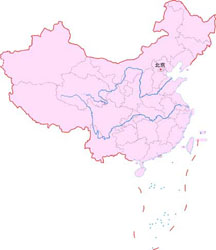
||
| 1: 500,000 topographic map coverage map | |||
1: 250,000 topographic map |
|||
 |
The 1: 250,000 topographic map comprehensively and systematically reflects the natural geographical conditions and economic profiles of the region. It is mainly used by various departments for overall regional planning, survey planning, resource development and utilization, and physical geographical survey in a relatively large area. It can also be used for national defense construction. It can also be used as the basic data for compiling smaller scale topographic maps or thematic maps. The1: 250,000 topographic map adopts Gauss-Kruger projection, 6 ° zoning, and compilation method. The division and numbering are based on 1: 1,000,000 topographic map. Each 1: 1,000,000 topographic map is divided into 4 rows and 4 columns, totaling 16 1: 250,000 topographic maps. 1, 2 … 16 indicates that the number of 1: 250,000 topographic map is obtained by adding the code of 1: 250,000 topographic map after the number of 1: 1,000,000 topographic map. Such as J-50- 2. The new standard adds the scale letter and line number of 1: 250,000 topographic map after the 1: 1,000,000 topographic map number. For example: J50C001004. Each 1: 250,000 topographic map has a range of 1 ° 30 ′ in longitude and 1 ° in latitude. |
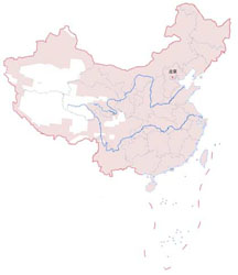
||
| 1: 250,000 topographic map coverage map | |||
1: 100,000 topographic map |
|||
 |
1: 100,000 topographic map is mainly used for detailed study and evaluation of topography within a certain range. For the survey, planning, design, scientific research and teaching of various departments of the national economy, such as industry, agriculture, forestry, water conservancy, railways, highways, land reclamation, animal husbandry, petroleum, coal, geology, meteorology, earthquake, environmental protection, culture, health, education, sports, civil aviation, medicine, customs, taxation, archaeology, land, etc; It is also the tactical map of the army, which is used for military activities such as field survey, training, map operation, compilation of military essentials, planning and design of national defense projects, and is also the basic data for compiling smaller scale topographic maps or thematic maps. The1: 100,000 topographic map adopts Gauss-Kruger projection, 6 ° zoning, and is mapped by the compilation method. The division and numbering are based on the division and numbering of the 1: 1,000,000 map. Each 1: 1,000,000 topographic map is divided into 12 rows and 12 columns, with a total of 144 1: 100,000 topographic maps, represented by 1 ~ 144. The code of the 1: 100,000 topographic map is added after the number of the 1: 1,000,000 topographic map. This is the number of the 1: 100,000 topographic map. Such as H-48-142, 8-48-142. The new division standard adds the scale letter and row and column number of 1: 100,000 topographic map after the 1: 1,000,000 topographic map number. For example: J50D012004. Each 1: 100,000 topographic map has a range of 30 ′ in longitude and 20 ′ in latitude. |
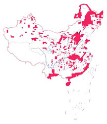
||
| 1: 100,000 topographic map coverage map | |||
1: 50,000 topographic map |
|||
 |
The 1: 50,000 topographic map is the basic map for various departments of our national economy and national defense construction. This kind of scale topographic map is mainly used for detailed study and evaluation of topography within a certain range. For the survey, planning, design, scientific research and teaching of various departments of the national economy, such as industry, agriculture, forestry, water conservancy, railways, highways, land reclamation, animal husbandry, petroleum, coal, geology, meteorology, earthquake, environmental protection, culture, health, education, sports, civil aviation, medicine, customs, taxation, archaeology, land, etc; It is also the tactical map of the army, which is used for military activities such as field survey, training, map operation, compilation of military essentials, planning and design of national defense projects, and is also the basic data for compiling smaller scale topographic maps or thematic maps. The1: 50,000 topographic map adopts Gauss-Kruger projection, 6 ° zoning, and is mapped by aerial photogrammetry. The division and numbering are based on the 1: 100,000 topographic map. Each 1: 100,000 topographic map is divided into two rows and two columns, totaling four 1: 50,000 topographic maps. Before the 1970s, it was represented by A,, В or A, B, C, D, and in the 1970s and 1980s, it was represented by A, B, C, D. The number of 1: 50,000 topographic map is obtained by adding the code of 1: 50,000 topographic map after the number of 1: 100,000 topographic map. For example: H-48-142-Г, 8-48-142-J, H-48-142-D. According to the new division standard, each 1: 1,000,000 topographic map is divided into 24 rows and 24 columns, totaling 576 1: 50,000 topographic maps. The number of the 1: 50,000 topographic map is obtained by adding the scale code and the row and column number of the 1: 50,000 topographic map after the number of the 1: 1,000,000 topographic map. Example: J50E017016. Each 1: 50,000 topographic map has a longitude difference of 15 ′ and a latitude difference of 10 ′. |
||
| 1: 50,000 topographic map coverage map | |||
1: 25,000 topographic map |
|||
 |
The 1: 25,000 topographic map is mainly used for detailed study and evaluation of topography in a relatively small area, planning and design of urban, township, rural and mine construction, forest spot survey, cadastral survey, large-scale geological survey and general survey, survey, planning and design of hydropower projects, scientific research, and special needs of national defense construction. It can also be used as the basic data for the compilation of smaller scale topographic maps or thematic maps. The1: 25,000 topographic map is mapped by means of Gauss-Kruger projection, 6 ° zoning, aerial photogrammetry or compilation. The division and numbering are based on the 1: 50,000 map. Each 1: 50,000 topographic map is divided into 2 rows and 2 columns. There are 4 1: 25,000 topographic maps in total, which are represented by a,, or 1, 2, 3, 4. The number of the 1: 25,000 topographic map is obtained by adding the code of the 1: 25,000 topographic map after the number of the 1: 50,000 topographic map. For example: J-50-144-A-, 10-50-144-A-2, J-50-144-A-2. The new division standard is based on 1: 1,000,000, which is divided into 48 rows and 48 columns, totaling 2304. The number of 1: 25,000 topographic map is obtained by adding the scale code and row and column number of 1: 25,000 topographic map after the number of 1: 1,000,000 topographic map. Example: J50F045004. Each 1: 25,000 topographic map has a longitude difference of 7 ′ 30 ″ and a latitude difference of 5 ′. |
||
| 1: 25,000 topographic map coverage map | |||
1: 10,000 topographic map |
|||
 |
1: 10,000 topographic map is mainly used for detailed study and evaluation of topography in a small area, planning and design of urban, township, rural and mine construction, forest spot survey, cadastral survey, large-scale geological survey and general survey, survey, planning and design of hydropower projects, scientific research, and special needs of national defense construction. It can also be used as the basic data for the compilation of smaller scale topographic maps or thematic maps. The1: 10,000 topographic map is mapped by means of aerial photogrammetry with Gauss-Kruger projection and 3 ° zoning. Framing and numbering: Before the 1970s, based on the 1: 25,000 topographic map, each 1: 25,000 topographic map was divided into 2 rows and 2 columns, totaling 4 1: 10,000 topographic maps, represented by 1, 2, 3 and 4, and the code of 1: 10,000 topographic map was added after the number of 1: 25,000 topographic map. This is the number of the 1: 10,000 topographic map. For example, J — 50 — 144 — A — 1. In the 1970s and 1980s, based on 1: 100,000 topographic maps, each 1: 100,000 topographic map was divided into 8 rows and 8 columns, totaling 64 1: 10,000 topographic maps, with (1), (2) … (64) indicates that the number of 1: 10,000 topographic map is obtained by adding the code of 1: 10,000 topographic map after the number of 1: 100,000 topographic map. E.g. J — 50 — 144 — (1). Since the 1990s, based on 1: 1,000,000 topographic maps, each 1: 1,000,000 topographic map has been divided into 96 rows and 96 columns, totaling 9216 1: 10,000 topographic maps, and the scale code and row and column number of the 1: 10,000 topographic map are added after the 1: 1,000,000 topographic map number. This is the number of the 1: 10,000 topographic map. Example: J50G093004. Each 1: 10,000 topographic map has a longitude difference of 3 ′ 45 ″ and a latitude difference of 2 ′ 30 ″. |
||
| 1: 10,000 topographic map coverage map | |||
1:50 million topographic map |
|||
|
|
1:5000 topographic map is mainly used for detailed study and evaluation of topography in a small area, which can be used by various departments for survey, planning, design and scientific research, and can also be used as basic data for compiling smaller scale topographic maps or thematic maps. The1:5000 topographic map adopts Gauss-Kruger projection, 3 ° zoning, and its subdivision and numbering are based on the 1:1000000 topographic map. Each 1:1000000 topographic map is divided into 192 rows and 192 columns, and there are 36864 1:5000 topographic maps in total. The serial number of 1:5000 topographic map is obtained by adding the scale code and row and column number of 1:5000 topographic map after the serial number of 1:1000000 topographic map. J50H093093. The range of each 1:5000 topographic map is longitude difference 1 ′ 52.5 ″ and latitude difference 1 ′ 15 ″. |
||
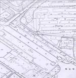
| 1:5000 Topographic Map Schematic Diagram of Urban Residential Area | |||
 |
 |
 |
1:500, 1:1000 and 1:2000 topographic maps are mainly used for accurate research and evaluation of topography in a small area, and can be used for survey, planning, design and construction. Gauss-Kruger projection is used forplane control, and the plane rectangular coordinates are calculated according to 3 ° zoning. When there are special requirements for the control network, any meridian is used as the independent Coordinate System of Prime Meridian, and the projection plane is also the local elevation reference plane. Frame numbering: square or rectangular, 50cm × 50cm or 40cm × 40cm. The drawing number shall be numbered with the coordinate kilometers of the southwest corner of the drawing outline as the unit, with X in the front and Y in the back, and connected by short lines in the middle, such as 1:2000, 10. 0—21. 0;1:1000,10. 5—21. 5;1:500,10. 50—21. 75。 Map sheets of zonal or small-area survey areas shall be numbered according to the unified sequence of survey areas. |
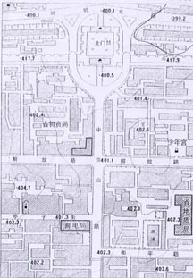
| 1:500 Topographic Map Schematic Diagram of Urban Residential Area | 1:1000 topographic map Sketch map of rural residential area | 1:2000 Topographic Map Schematic Diagram of Urban Overpass | |
Note: This document is compiled on the website of the State Bureau of Surveying and Mapping, and is only used as a reference for users.