


Trapezoid Framing and Numbering of National Basic Scale
Sheet No. Of 1.1: 1,000,000 Topographic Map
The division and numbering of 1 ∶ 1 000 000 topographic map are based on the international Standard Map Sheet with longitude difference of 6 ° and latitude difference of 4 °. From the equator northward or southward to latitude 88 degrees, 22 horizontal rows are drawn every 4 degrees of latitude difference, followed by A, B.. , V; from longitude 180 ° to the east, a longitudinal line is drawn every 6 ° according to the longitude difference, and the whole world is divided into 60 longitudinal lines, which are represented by 1, 2, … … , 60 indicate. The number of each drawing is composed of the "column number-row number" of the drawing. For example, the longitude of a place in Beijing is 116 ° 26 ′ 08 ″, the latitude is 39 ° 55 ′ 20 ″, and the number of the 1 ∶ 1 million topographic map is J-50.
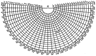 |
| Figure: Sheet number of 1: 1,000,000 topographic map |
2. Subdivision and numbering of 1: 500,000, 1: 250,000 and 1: 100,000 scale topographic maps
These three kinds of topographic maps are numbered on the basis of 1:1 million topographic maps:
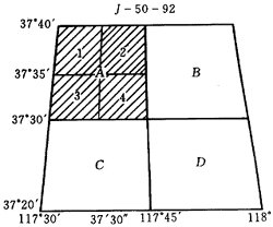
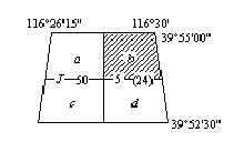
- 1: 500,000 map: according to the longitude difference of 3 ° and the latitude difference of 2 °, a 1: 1,000,000 map can be divided into 4 maps, which are represented by codes A, B, C and D respectively. The number of the 1:1 million map sheet plus the code is the number of the code map sheet, for example, the number of the 1: 500,000 map sheet is J-50-A.
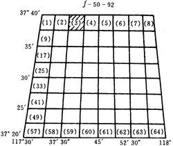
- 1: 250,000 map: according to the longitude difference of 1 ° 30 'and the latitude difference of 1 °, a map of 1: 1,000,000 can be divided into 16 maps of 1: 250,000, using 1, 2, … … , 16 code representation. Add the code to the number of the 1:1 million map sheet, which is the number of the map sheet of the code. For example, the number of the 1: 250,000 map sheet is J-50- 1.
- The map of 1: 100,000 is divided into 144 maps of 1: 100,000 according to the longitude difference of 30 'and the latitude difference of 20'. 144 code representation. Add the code to the number of the 1:1 million map sheet, which is the number of the code map sheet. For example, the number of the 1: 100,000 map sheet is J-50-1.
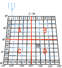 |
| Map: Division and numbering of 1: 500,000, 1: 250,000 and 1: 100,000 topographic maps |
3.1 Division and numbering of 50,000, 25,000 and 10,000 scale topographic maps
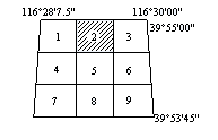
Both 1: 50,000 and 1: 10,000 topographic map numbers are composed of 1: 100,000 sheet numbers followed by their own codes. A 1: 100,000 topographic map is divided into four 1: 50,000 topographic maps according to the longitude difference of 15 'and the latitude difference of 10', and the codes are represented by A, B, C and D respectively after the code of 1: 100,000, such as H-48-5-A, B, C and D; A 1: 100,000 topographic map is directly divided into 8 rows and 8 columns according to the longitude difference of 3 '45 "' and the latitude difference of 2 '30"'. There are 64 1: 10,000 topographic maps in total. The numbering is to connect (1), (2), (3), … with a short horizontal line behind the sheet number of 1: 100,000 topographic map. , (64), such as H-48-5- (24).
A 1: 50,000 topographic map is divided into four 1: 25,000 topographic maps according to the longitude difference of 7 '30' and the latitude difference of 5 ', which are represented by 1, 2, 3 and 4 respectively. The number of the 1: 25,000 topographic map is connected with 1, 2, 3 and 4 by a short horizontal line after the number of the 1: 50,000 topographic map sheet, such as H-48-5-B-4. 1: 50,000 — 1: 10,000 topographic maps are numbered from left to right and from top to bottom, as shown in the figure below.
 |
 |
| Drawings: 1: 50,000, 1: 25,000 sheets and numbers | Figure: 1: 10,000 sheets and numbers |
4. Subdivision and numbering of large-scale topographic maps
The topographic map with a scale of 1:5000 is numbered on the basis of the topographic map with a scale of 1: 10,000, and each topographic map with a scale of 1: 10,000 is divided into four topographic maps with a scale of 1:5000 according to the longitude difference of 1 '52.5' and the latitude difference of 1 '15'. It is numbered by adding the lowercase Latin letters a, B, C, d to the number of the 1: 10,000 topographic map.
The topographic map with a scale of 1:2000 is divided and numbered on the basis of the topographic map with a scale of 1:5000. Each topographic map with a scale of 1:5000 is divided into nine topographic maps with a scale of 1:5000 by longitude difference of 37.5 "and latitude difference of 25", and the topographic map with a scale of 1:5000 is numbered by adding short lines according to the topographic map with a scale of 1:5000. Plus 1, 2, 3, 4, 5, 6, 7, 8, 9. As shown in the following figure:
 |
 |
| Figure: Sheet and number of 1:5000 | Figure: Sheet and number of 1:2000 |
Subdivision and Numbering of National Basic Scale Topographic Map
China issued the national standard of "New Subdivision and Numbering of National Basic Scale Topographic Maps GB/T13989-92" in December 1992, which has been implemented since March 1993. The newly surveyed and updated Basic Scale topographic maps must be divided and numbered according to this standard. The new sheet numbering has the following characteristics compared with the previous one:
- The 1:5000 topographic map is listed in the National Basic Scale Topographic Map Series. There are eight kinds of Basic Scale topographic maps: 1: 1,000,000, 1: 500,000, 1: 250,000, 1: 100,000, 1: 50,000, 1: 25,000, 1: 10,000 and 1:5000.
- Although the division is still based on the 1: 1,000,000 topographic map and the difference between longitude and latitude is not changed, the division method is different, that is, all of them are divided on the basis of the 1: 1,000,000 topographic map. In addition, the column (latitude) and row (longitude) in the past are now renamed as row and column.
- The numbering is still based on the 1: 1,000,000 topographic map number, followed by the code of the scale, and then the code corresponding to the row (latitude) and column (longitude) of the corresponding scale map sheet. Therefore, all 1: 5000-1: 500,000 topographic maps are numbered with a five-element 10-digit code. The coding series are unified into one root, the coding length is the same, and the computer processing and identification are very convenient.
The division of 1: 1,000,000 topographic map is carried out according to the international standard for division of 1: 1,000,000 topographic map. Other scales are divided on the basis of 1: 1,000,000. The division of 1: 1,000,000 topographic map into topographic maps of other scales is shown in Table 1:
| Scale | Meridian difference | Latitude difference | Number of rows and columns | Number of map sheets | Frame code | Numbering example |
| 1:1,000,000 | 6° | 4° | 1×1 | 1 | Verticals: 1, 2, 3.., 60 Rows: A, B, C.., V |
J-50 |
| 1:500,000 | 3° | 2° | 2×2 | 4 | A,B,C,D | J-50-A |
| 1:250,000 | 1°30' | 1° | 4×4 | 16 | 1,2,3,...,66 | J-50-3 |
| 1:100,000 | 30' | 20' | 12×12 | 144 | 1,2,3,...,144 | J-50-5 |
| 1:50,000 | 15' | 10' | 24×24 | 576 | A,B,C,D | J-50-5-B |
| 1:25,000 | 7'30" | 5' | 48×48 | 2304 | 1,2,3,4 | J-50-A-2 |
| 1:10,000 | 3'45" | 2'30" | 96×96 | 9216 | (1),(2),(3),...,(64) | J-50-5-(15) |
| 1:5000 | 1'52.5" | 1'15" | 48×48 | 36864 | a,b,c,d | J-50-5-(15)-c |
Topographic Map Number
There is no change in the new numbering method of 1:1 million topographic map except that the row number and column number are changed to continuous writing. For example, the drawing number of 1:1 million topographic map where Beijing is located is changed from J-50 to J50.
Chinese Basic Scale Code:
| Scale | 1:500,000 | 1:250,000 | 1:100,000 | 1:50,000 | 1:25,000 | 1:10,000 | 1:5000 |
| Code | B | V | D | E | F | G | H |
Numbering of 1: 500,000 to 1: 5,000 topographic maps is based on the numbering of 1: 1,000,000 topographic maps. The determinant numbering method is used to divide the 1: 1,000,000 topographic maps into corresponding rows and columns according to the longitude and latitude differences of the topographic maps of various scales contained in the maps. The horizontal rows are From top to bottom and the vertical columns are from left to right. Arabic numerals shall be used for numbering in order, and all numbers shall be represented by 3 digits. If the number is less than 3 digits, 0 shall be added before it.
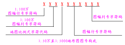
The map number of each large and medium scale topographic map is composed of five element 10-digit codes. From left to right, the 1-bit code of the first element is the character code of 1: 1,000,000 map sheet row number; the 2-bit code of the second element is the numerical code of 1: 1,000,000 map sheet column number; the 1-bit code of the third element is the character code of the corresponding scale of the numbered topographic map; the 3-bit code of the fourth element is the numerical code of the map sheet row number of the numbered topographic map; the 3-bit code of the fifth element is the numerical code of the map sheet column number of the numbered topographic map; Each element is connected (as shown in Figure 2-1). See Fig. 2-2 for scale code;
 |
| Map: Map number composition of 1: 500,000 to 1: 5,000 topographic map |