Open iServer Terrain Layer
Instructions for use
The Open iServer Terrain Layer "command is used to use the Terrain DataAdd to Scene in the published iServer service scenario as the Terrain Layer in the scenario.
Operation steps
- Right-click the root node of Terrain Layer in Layer Manager, and select the Open iServer Terrain Layer command in the pop-up Context Menu.
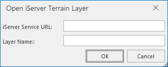
- The Open iServer Terrain Layer "dialog box pops up. Enter the address and name of the Terrain Data in the iServer service scenario you published, and then click OK in the dialog box to open the Terrain Data.

Figure: Open iServer Terrain Layer. - Server Address: Enter the address published by the iServer service Terrain Layer.
- Layer Name: Enter the name of the Terrain Layer for the service published through the iServer. This name is an alias for the layer and can be different from the Layer Name at the time of publishing.
- The newly loaded Terrain Data is displayed on the simulated earth in the scene as a Terrain Layer in the scene, and a child node of the Terrain Layer "is added in the Layer Manager. This node corresponds to the Terrain Data layer of the iServer service scenario just opened.
Remark
When the scene service Terrain Layer is requested, URL (iServerServer Address) is a http://Service. Address: port number/iserver/services/realspace-workspace name/rest/realspace/datas/Terrain Layer name, http://localhost:8090/iserver/services/realspace-sample/rest/realspace/datas/Beijing@RealspaceSample_Terrain。


