


3D Spatial Query
Instructions for use
3D Spatial Query involves Query Layer, Query Conditions and Query Object, and implements querying and specifying all Model Objects with Query Conditions in Query Layer.
Spatial Query of point and Model Object is currently supported.
Operation steps
- Select the query object in the Scene, which can be a single or multiple models.
- Click the Spatial Query Drop-down Button in the 3D Analysis functional group on the 3D Geographic Design tab and click 3D Spatial Query from the drop-down menu. The 3D Spatial Query "dialog box pops up, as shown in the following figure.
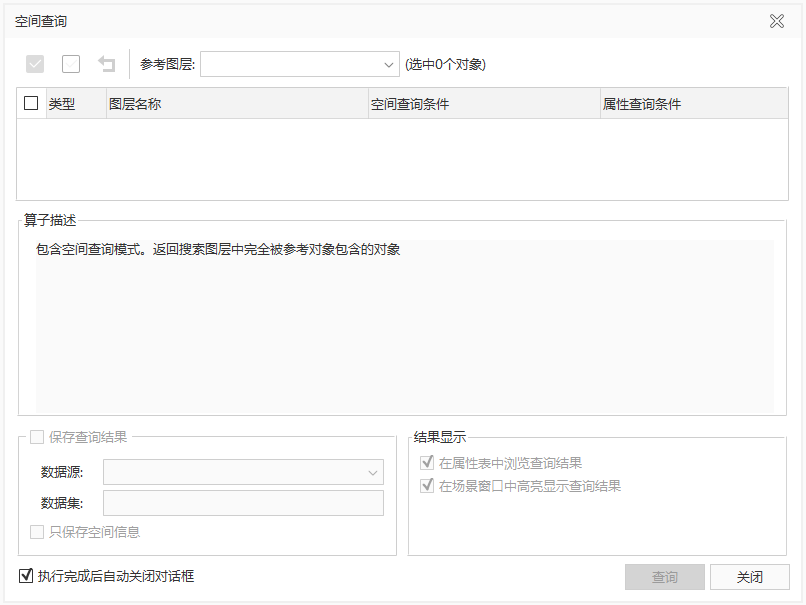
Figure: 3D Spatial Query "dialog box - The
- selected query Layer of Object is automatically loaded into the Reference Layer "drop-down list box and the searched layer list below.
- Support the modification of query objects in the scene, and the information in the search layer list and the searched layer list will be updated in real time.
- Target Layer can be selected or not selected in batch through the toolbar, and Target Layer can also be selected or not selected independently.
- Select the final query Layer of Object in the search layer list, and the layer ID (SMID) is updated in real time.
- Set Query Conditions, including Spatial Query Condition and Attribute Query Condition.
- Attribute Query Condition: In the searched layer list, click Attribute Query Condition "Drop-down Button to pop up the SQL Expression" dialog box. Construct the Property FieldQuery Conditions of the searched layer, that is, the objects that meet the conditions participate in Spatial Query. If Attribute Query Condition is not set, All Objects in the layer will participate in Spatial Query.
- Spatial Query Condition: In the searched layer list, click Spatial Query Condition "Drop-down Button, Select a supported Spatial Query operator from the drop-down list. At present, there are six kinds of Spatial Query operators supported by Application, namely, inclusion, separation, coincidence, intersection, inclusion, and Intersects or Contains. Select the corresponding Spatial Query operator, and the corresponding Operator Description will be displayed under the searched layer list.
- Set how the Search Result is saved. When "Save Results" is checked, you can set the stored Datasource and Dataset, and whether to Only Save Spatial Info.
- Datasource: Used to set and display the Target Datasource to be saved by Search Result. All non-read-only Datasources in the Current Workspace are listed in the drop-down list, and the user can specify a Target Datasource to save the Result Dataset.
- Dataset: Used to set and display the name of the new Dataset. The default name is: SpatialQuery.
- Only Save Spa tial Info: Check the "Only Save Spatial Info" "check box to save only the Spatial Info of the Results and not its Attributes.
- Set the way to query Show Results. Highlight the query result in the scene window "is checked by default. When two check boxes are checked at the same time, 2D and 3D linkage browsing Search Result can be realized.
- Browse in Attribute Table: Select the check box to open the Search Result as an attribute table.
- Highlight the query result in the scene window: Select the check box to Highlight the query result in the scene window.
- When you are finished, click the Query button to execute the Spatial Query operation.
- Click the Close button to close the Spatial Query dialog box.
 Caution:
 - The 3D Spatial Query "Function Button is available
- only if a non-empty Model Dataest exists in the current scene. Spatial Query operation can be performed
- only when the search object and Reference Layer are in the same coordinate system.