


Instructions for use
Connect River System is a process that assigns a unique value to each river in a drainage system based on Raster River System and Direction Raster.
The connected water system network records the Connection Info of the water system nodes, which reflects the network structure of the water system. After Connection succeeded, each reach has a unique grid value. As shown in the figure below, the red point in the figure is the intersection point, that is, the intersection position of the river reach and the river reach. A reach is a portion of a river that connects two adjacent junctions, either a junction and a catchment, or a junction and a watershed.
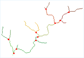 |
| Figure: Schematic diagram of Connect River System |
In the final Connect River System result, the linear network of the river grid should be Greater than or equal to 1, as shown in the following figure.
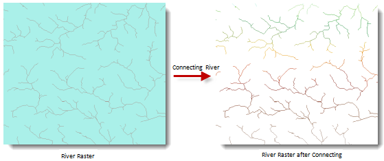 |
| Figure: Connect River System Results Graph |
Function entrance
- Spatial Analysis tab-> Raster Analysis group-> Hydrological Analysis-> Connect River System.
- Toolbox, Raster Analysis, Hydr ological Analysis, Connect River System.
Parameter Description
- River System Data: Select the Datasource and Dataset where the Raster River System is located.
- Flow Direction Data: Select Datasource and Dataset where Flow Direction Data is located. For how to generate Flow Direction Data, see Calculate Flow Direction.
- Result Data: Set the name of the Datasource and Dataset to save the result.
- Click the Execute button to execute the prepared analysis function. After the execution completed, the Output Window will prompt whether the Result succeeds or fails.