


Instructions for use
Extract Raster River System is the first step to extract the drainage network. The following Stream Order, Connect River System, and River System Vector ization operate based on the Raster River System.
As we know, the pixels with higher Cumulative Flow Accumulation can be regarded as river valleys. By setting a threshold for the catchment, the pixels with Cumulative Flow Accumulation greater than threshold are extracted, and the Raster River System is obtained. In the actual operation process, the threshold may be different for different levels of valleys and the same level of valleys in different regions, so the threshold should be determined according to the actual topography of the study area and through continuous experiments.
According to the previous introduction, Raster River System can be extracted by Algebraic Operation on Cumulative Flow Accumulation grid. Assuming that an area with a Cumulative Flow Accumulation of more than 2000 is determined as a catchment area through investigation, the expression of the Extract Raster River System is:
Data source. Cumulative Flow Accumulation Grid > 2000
After calculation, the Raster River System is obtained, which is a binary grid. The pixels with Cumulative Flow Accumulation greater than 2000 are assigned to 1, and the other pixels are assigned to 0. A value of 0 indicates no value.
As shown in the figure below, it is the extracted Raster River System:
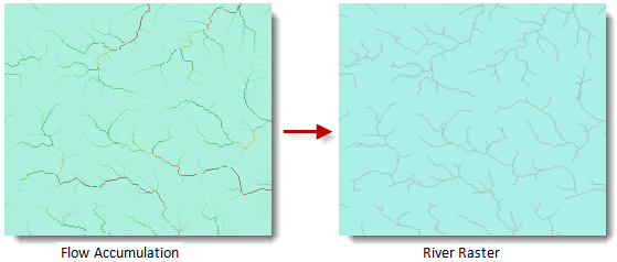 |
| Figure: Raster River System Extraction Result. |
Function entrance
- Spatial Analysis tab-> Raster Analysis group-> Hydrological Analysis-> Extract Raster River System.
- Toolbox, Raster Analysis, Hydr ological Analysis, Extract Raster River System.
Parameter Description
- Flow Accumulation Data: Select the Datasource and Dataset where the catchment grid is located.
- Threshold: Enter the threshold of the Cumulative Flow Accumulation to be extracted.
- Pixel Format: The application provides 8 kinds of Pixel Formats, including 1-bit, 4-bit, single-byte, double-byte, integer, long integer, Single and Double. Refer to the Raster DatasetPixel Format for a description of each format.
- Ignore NoValue Cells: After this check box is checked, the grid cell with no value in the input Raster Dataset will not participate in Algebraic Operation, and the pixel value at the corresponding position in the Result Dataset is still null (usually -9999); If this item is not checked, Application will take the pixel value of the grid cell with no value as the normal pixel value to participate in the operation, which will cause the minimum value (or maximum value) of the Result Raster Dataset to change. Default Ignore NoValue.
- Compress Dataset: After this check box is checked, Application will compress and store Result Dataset, otherwise, it will not compress and store Result Dataset. By default, compression is not performed.
- Result Data: Set the name of the Datasource and Dataset to save the result.
- Click the Execute button to execute the prepared analysis function. After the execution completed, the Output Window will prompt whether the Result succeeds or fails.