


Depression refers to the local area surrounded by higher elevation in the basin. It is divided into natural depression and pseudo-depression. Natural depression is the actual depression in nature, which usually appears on the alluvial plain with flat terrain and large area, and is very rare in the area with large relief. Such as glaciers or karst landforms, mining areas, potholes, etc., which are normal. In the DEM data, the depressions produced by the error of Data Processing and the inappropriate interpolation method are called pseudo-depressions.
The vast majority of depressions in DEM data are pseudo-depressions. The false depression will affect the flow direction and cause the terrain Analyst Result error. Therefore, before Hydrological Analysis, the DEM data is usually filled with depressions. For example, when determining the direction of water flow, because the elevation of the depression is lower than that of the surrounding grid, the flow direction in a certain area will point to the depression, resulting in the accumulation of water flow in the depression and the interruption of the catchment network. The schematic section of the filled depression is as follows: of pseudo-depression section
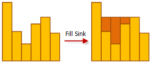 |
| Figure: Schematic diagram |
Therefore, before starting any Hydrological Analysis, it is recommended to carry out the pre-treatment of Fill Sinks, which is usually the premise of reasonable flow direction calculation.
Instructions for use
There are two scenarios for the Fill Sinks operation:
- Yeah, DEM Raster Data Fill Sinks. This method will fill up all depressions (including real depressions and false depressions) in the DEM Raster Data. Because there are very few real depressions, the filling of depressions has little impact on the subsequent analysis.
- These swale areas are assigned no value in the swale fill Result Raster, based on the known The Sink Data to be Excluded (point or Region Dataset) to the DEM Raster DataFill Sinks. This method is very suitable for the situation that there is a real depression in the analysis area. Using the location data (two-dimensional point or surface data) of the real depression, a more accurate pseudo-depression Fill Result will be obtained.
Function entrance
- Spatial Analysis tab-> Raster Analysis group-> Hydrological Analysis-> Fill Sinks.
- Toolbox-> Raster Analysis-> Hydr ological Analysis-> Fill Sinks.
Parameter Description
- Source Data: Set the Datasource and Dataset where the DEMs of the swales to be filled are located.
- The Sink Data to be Excluded: When this item is selected, the known depressions will be excluded, and these areas will not be filled; when this item is not selected, all depressions in the DGM will be filled, including pseudo depressions and real depressions. Excluded depressions are not used by default, and depressions are filled directly. When you
Fill Sinks, you can specify a point or a Region Dataset that represents a real swale or a swale to be excluded, which will not be filled. Using accurate data of this kind, a more realistic terrain without false depression will be obtained, which will make the subsequent analysis more reliable. If you select a Point Dataset, one or more of the points should be within a swale. Ideally, the point indicates the catchment point for the swale area. In the case of a Region Dataset, each face object should cover one swale area.
- Result Data: Set the Datasource and Dataset Name to save the result.
- Click the Execute button to execute the currently selected analysis function. After the execution completed, the Output Window will prompt whether the Result succeeds or fails.
Remark
- After filling a depression, it is possible to create a new depression. Therefore, filling a depression is an iterative process of repeatedly identifying and filling depressions until all depressions are filled and no new depressions are created. When the amount of DEM data is large or there are many depressions, it may take more time to fill the depressions.