


Drainage Basin is a catchment area and is one of the ways to describe a watershed. The Calculate Watershed Basin function is used to create a Raster Dataset that describes the Drainage Basin.
Instructions for use
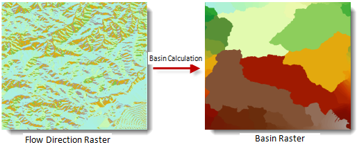
Calculate Watershed Basin is the process of assigning a unique basin to each pixel according to the Flow Direction Data, as shown in the figure below. Drainage Basin is one of the ways to describe the basin. Displays those grids that are all connected to each other and in the same Drainage Basin.
 |
It is generally believed that all the catchment points of the Drainage Basin are on the boundary of the grid, that is, the water flows outside the boundary. Therefore, during the Calculate Watershed Basin, each catchment point is determined first, and then the watershed is identified according to the water flow direction, so as to determine the boundary of the drainage basin. Finalize each Drainage Basin.
When creating a Direction Raster, it is easier to get the best results by using the Force Boundary Grid Flow Outward parameter. For a description of this parameter, see the Calculate Flow Direction .
Function entrance
- Spatial Analysis tab-> Raster Analysis group-> Hydrological Analysis-> Calculate Water shed Basin.
- Toolbox, Raster Analysis, Hydr ological Analysis, Calculate Watershed Basin.
Parameter Description
- Flow Direction Data: Select Datasource and Dataset where Direction Raster is located.
- Result Data: Set the name of the Datasource and Dataset to save the result.
- Click the Execute button to execute the prepared analysis function. After the execution completed, the Output Window will prompt whether the Result succeeds or fails.