


Overview of Data Registration
There are many kinds of geometric distortions in the imaging process of remote sensing Image Data, and the coordinates of the image/Raster Dataset need to be corrected by registration operation; Paper deformation exists in the process of saving paper maps, and the scanned drawings are prone to error deformation, and the scanned drawings of paper maps have no spatial location, so they need to be corrected to Geographic Coordinate System or projection coordinate system through data registration, and at the same time, geometric distortion and deformation errors can also be corrected. Achieve the unification of different DatasetGCSs in the same region. Another situation is that when multiple Datasets are analyzed, such as Image mosaic, Vector Data merging or superposition, all the Datasets involved in the analysis are required to be in the same coordinate system, and data registration is also required at this time.
Supports registration of single or multiple Datasets and Rapid Registration via Registration File (*.drfu).
Principle of data registration
Data registration is the process of correcting and transforming the spatial position of the registered Dataset (layer) through the Reference dataset (layer). The registration Dataset is registered through the determined registration algorithm and control point information, and the registration Result Dataset with the same spatial position as the Reference dataset (layer) can be obtained.
When the Reference Layer is specified, the appropriate registration point needs to be selected in the Registration Layer, and the control point also needs to be selected at the corresponding position of the Reference Layer. The registration process will convert the registration point position in the Registration Layer to the spatial position consistent with the Reference Layer through a certain registration algorithm. Without specifying the Reference Layer, it is necessary to select appropriate registration points on the Registration Layer and enter the coordinates of the control points at the positions corresponding to the registration points on the Input Control Points dialog.
Data registration process
Step 1 Create New Registration : Select one or more registration data to establish the registration relationship between Registration Layer and Reference Layer.
The second step is to select control points. , the process of pricking, is the Crucial Step of registration. Select the same point of the feature in the same spatial position on the Registration Layer and the Reference Layer. Registration can also be performed by importing an existing control point Registration File (*.drfu).
Step 3 Calculate Error : Select the registration calculation to calculate the registration error. Application will calculate X residual, Y residual, RMSE and root mean square total error of all control points, and verify the accuracy of control point selection.
Step 4 Perform registration : Perform registration when Calculate Error is within the required range of registration accuracy. It also supports the export of Registration File.
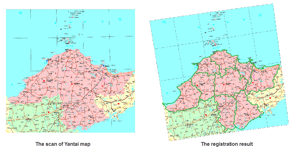
Application examples:
The scanned map of Yantai City is registered to make it consistent with the vector Region Dataset (Reference Layer) coordinate system of Yantai City and well matched with the scanned image. The effect of the registration result and the overlay display of the Reference dataset is shown in the following figure. The base image is the scanned image after registration, the green line is the Reference dataset, the yantaiR Region Dataset is used, and the transparent display processing is performed on it.
 |