


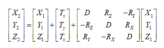
Coordinate Transformation models supported by SuperMap desktop products are Position Vector (7-para), Coordinate Frame (7-para), China _ 3D _ 7P (7-para) (three-dimensional seven-parameter transformation model), China _ 2D _ 7P (7-para) and China _ 2D _ 4P (4-para).
Transformation model
- Position Vector (7-para), Coordinate Frame (7-para): These two methods are commonly referred to as seven-parameter transformation, or Bursa Model. Includes three translation Transformation Parameters, three rotation Transformation Parameters, and one scale change parameter. Both of them can be regarded as a model, but different countries have different criteria for defining the sign of rotation.
- Position Vector, European definition, counterclockwise rotation is negative.
- Coordinate Frame (Coordinate Frame Rotation Transform), defined for the United States and Australia, with positive counterclockwise rotation.
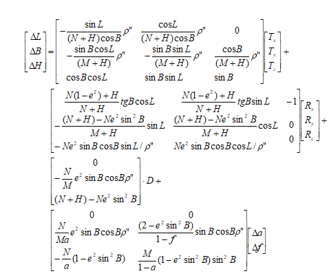
- China _ 3D _ 7P (7-para): The three-dimensional seven-parameter transformation model is used for the Coordinate Transformation of points between geodetic coordinate systems under different earth ellipsoid datums, involving three translation parameters, three rotation parameters and one scale change parameter. At the same time, the Semimajor Axis and the flattening difference of the two Earths corresponding to the two geodetic coordinate systems shall be taken into account.
- China _ 2D _ 7P (7-para): The two-dimensional seven-parameter transformation model is used for the Coordinate transformation of points from the geocentric coordinate system to the geodetic coordinate system under different earth ellipsoid datums, involving three translation parameters, three rotation parameters and one scale change parameter.
- China _ 2D _ 4P (4-para): Two-dimensional four-parameter transformation model is used for Coordinate transformation of different Gaussian projection planes in a local area, involving two translation parameters, one rotation parameter and one scale parameter. For 3D coordinates, the coordinates shall be transformed into plane coordinates through Gaussian projection, and then the Transformation Parameters shall be calculated.
Scope of application
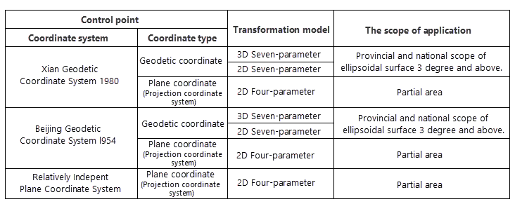
As the selection of the conversion model is affected by the coordinate system of the control points and the conversion area, the user can refer to the Scope of application of the conversion model given in the Technical Regulations for Geodetic Measurement Control PointCoordinate Transformation. And selecte a conversion model according to that coordinate system to which the source data control point belong and the applicable area range of the conversion model.
- Position Vector (7-para), Coordinate Frame (7-para): applicable to conversion of control point Space Rectangular Coordinate of provincial and National Area.
- China _ 3D _ 7P (7-para): Applicable to Coordinate Transformation of provincial and National Area control points with ellipsoidal surface of 3 ° and above.
- China _ 2D _ 7P (7-para): Applicable to Coordinate Transformation of provincial and National Area control points with ellipsoidal surface of 3 ° and above.
- China _ 2D _ 4P (4-para): It is applicable to the plane Coordinate Transformation of control points in a small area and the connection between the relatively independent Planar Coordinate System and the 2000 National Geodetic Coordinate System.
The following table shows the selection of Coordinate Transformation model and Scope of application for converting the control points of different coordinate systems to the 2000 national geodetic coordinate system:
 |
Application Scenario
Through SuperMap desktop, users can convert a local coordinate system Data Conversion to 2000 national geodetic coordinate system, and can realize the conversion results under different coordinate systems without other plug-ins.
- If the local coordinate system is based on the deflection of a general coordinate system (for example, Xian 1980, Beijin 1954, etc.). To convert the local coordinate system to the national geodetic coordinate system 2000, the local coordinate system needs to be converted to the actual general coordinate system first, and then converted from the general coordinate system to the national geodetic coordinate system 2000. This is done in the SuperMap desktop by:
- If the local coordinate system is based on a real coordinate system under a certain projection zone, the local coordinate system can be directly converted into the 2000 national geodetic coordinate system through the above step 2.
Step 1: Convert the local coordinate system to the universal coordinate system: Select a two-dimensional four-parameter (China _ 2D _ 4P) conversion model through Dataset Projection Transformation function ". Convert the local coordinate system to the actual general coordinate system.
Step 2: Convert the universal coordinate system to the 2000 national geodetic coordinate system: You can use the "< a < B =" "class =" contentpage hyperlink "href =" ">" Calculate Transformation Model Parameters ". calculates the Transformation Parameters, and then through the "Dataset Projection Transformation Function", The transformation models of two-dimensional seven-parameter (China _ 2D _ 7P), three-dimensional seven-parameter (China _ 3D _ 7P) and CoordinateFrame are selected to realize the transformation from the general coordinate system to the 2000 national geodetic coordinate system.
Model expression
- Position Vector(7-para)、Coordinate Frame (7-para)
- China_3D_7P(7-para)
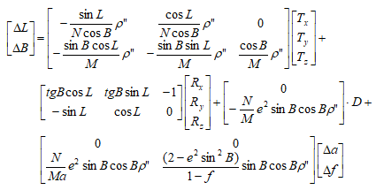
- China_2D_7P(7-para)
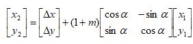
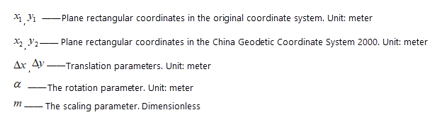
- China_2D_4P(4-para)
 |
 |
 |
 |
 |
 |
 |
 |
Note:
|
Related topics
Dataset Projection Transformation
Batch Projection Transformation
Model Transformation Parameter Calculation