


Application background
When the area to be studied and analyzed is very large, or the Target of interest is widely distributed, involving multiple Raster Data or multiple images, the user needs to splice multiple Raster Data or Image Data. In SuperMap iDesktop, you can perform Grid/Image splicing through Raster Splice, Raster Append, and Raster Mosaic. Raster Dataset is described below.
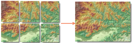 |
| Figure: Raster Mosaic |
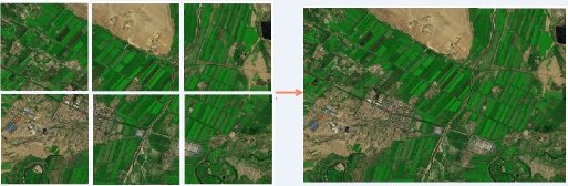 |
| Figure: Image Append |
Raster Splice
Through the Raster Splice function, multiple Raster Data can be quickly spliced to generate a new Raster Dataset; for detailed operation instructions, please refer to Raster Splice. When performing Raster Splice, the following points should be noted:
- The coordinate system of the input data to be spliced shall be consistent;
- The Pixel Format of the input data to be spliced shall be consistent.
- If the input data to be spliced is Image Data, the number of bands shall be consistent.
Grid Append
Grid append is to append multiple Raster Data to an existing target Raster Dataset in append import mode during Data Import. First, you need to create an empty Raster Dataset that meets the conditions. Because Raster Data is read-only data, the range, Pixel Format and band number of Raster Dataset are read-only and cannot be modified once it is created. So before you want to Append, you must create a Target Dataset that meets the conditions and Specify the Range.
Step 1: New Raster Dataset
The format of the data will not be changed in the Append process, so the created Raster Dataset attributes must be consistent with the Raster DataAttributes to be imported, otherwise Append will fail. Specific attribute parameters are described as follows:
- Dataset Bounds: The maximum range of all Raster Data in Append, in the same units as the Import Data coordinate system. For example, if the user imports multiple Raster Data of the whole Sichuan Province, the provincial boundary range can be used as the Dataset range.
- Pixel Format: Same as the Pixel Format to be imported into Raster Data.
- Band number: if the created Image Dataset, the band number shall be the same as the band number of the Data to be imported.
- X/Y resolution: The resolution of the target Raster Dataset can be different from the resolution of the Data to be imported: when the resolution of the Target Dataset is low, the resolution of the Raster Data to be imported is high. The imported Raster Dataset resolution is consistent with the Target Dataset resolution as low resolution. When the resolution of Target Dataset is high and the resolution of Raster Data to be imported is low, the resolution of the imported Raster Dataset and the resolution of Target Dataset are the same as the high resolution.
- Users of the above data Attributes can directly open a Raster Data to be imported as a file Datasource and view it in the Properties Panel.
- Create an empty Dataset and then grid Append its Create Pyramid to improve efficiency.
- If the user already has a target Raster Dataset that meets the range and attribute parameters, there is no need to New Raster Dataset again, and the second step is entered directly.
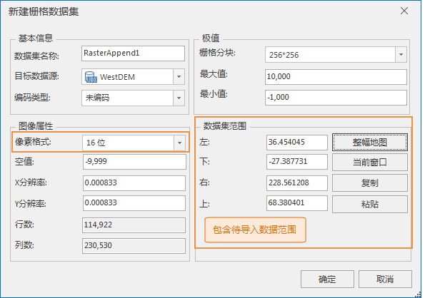 |
| Figure: New Raster Dataset. |
Note:
Step 2: Import multiple grid Data into the created target Raster Dataset.
- Add the Raster Data to be Appended to the list box through the Data Import function.
- To append Dataset and Target Dataset, the following conditions must be met:
- To Import Raster must have same coordinate system.
- Result Dataset: The Result Dataset is the same as the target Raster Dataset created in the previous step.
- Dataset Type: The appended Dataset Type must be consistent.
- Import Mode: Set Append.
- Data Band Mode: The band mode of Append shall be consistent with the original data band mode, and shall be single multi-band, multi-band or Composite Band.
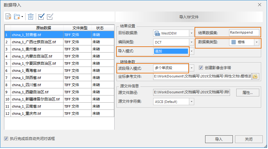 |
| Figure: Data Import |
Use the above two steps to complete the grid Append.
Raster Mosaic
Multiple Raster Datasets can be spliced together through the Raster Mosaic operation; for mosaic processing, the grid to be mosaic needs to be imported in the form of Dataset before mosaic processing. Refer to Raster Mosaic for detailed operating instructions. When performing a Raster Data tessellation, the following points need to be noted:
- The grid to be tessellated must have the same coordinate system: Tessellation requires that all Raster Dataset or Image Dataset have the same coordinate system, otherwise the tessellation result may be wrong.
- Processing of overlapping area: During mosaic, there is often an overlapping area between two or more pieces of Raster Data. In this case, you need to specify the value method for the grid of the overlapping area. The program provides five ways to get the value of the overlapping area, and the user can choose the appropriate way according to the actual needs.
- When Mosaic Data is Raster Dataset, no value and no value tolerance can be specified; That is, when the values of the cells in the Raster Dataset participating in the tessellation are in the Bounds Settings of the data without values, these cells are null in the corresponding positions of the Result Dataset.
- When the Mosaic Data is an Image Dataset, you can specify the background color and its tolerance. When a cell of this color is encountered during the Raster Mosaic operation, it is regarded as the background color.
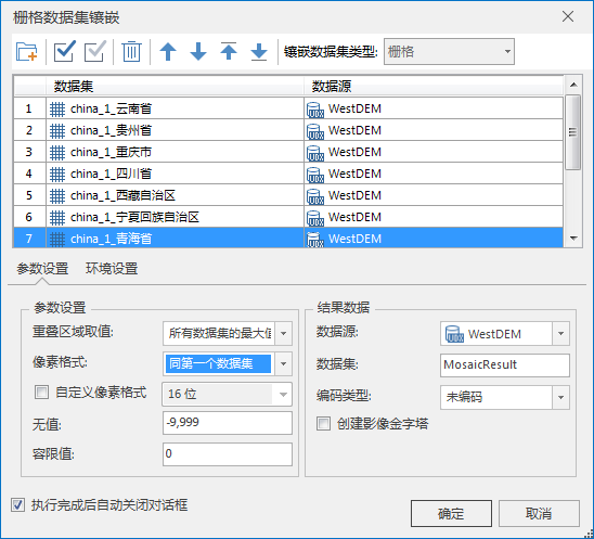 |
| Figure: Raster Mosaic |
Application example
The DEM Raster Data of 12 provinces in China are selected, and the size of the file is 4. 42 G. Raster Splice, Raster Append and Raster Mosaic are used to merge the 12 Raster Data into one Raster Dataset.
Raster Splice time: 8 minutes and 20 seconds;
Grid Append Time: The import time is the same as Raster Splice, but the Dataset containing the Data range to be imported needs to be created first;
Raster Mosaic time: 1 hour and 42 minutes for grid import and Raster Mosaic;
1. Comparison of splicing efficiency
- Raster Splice: Data files to be imported can be directly added for rapid batch splicing operation, with the highest efficiency of Data Processing.
- Raster Append: Import Data by appending. The user needs to create a Dataset containing the range of Data to be imported in advance. Data append is realized at the same time of Data Import.
- Raster Mosaic: Import Data first and then perform mosaic. When the amount of data is large, it is time-consuming to perform mosaic after import.
2. Overlapping Area Processing Method
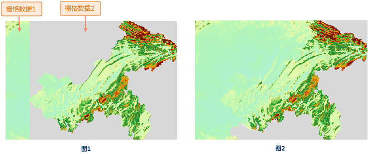
- Raster Splice and Raster Append process the overlapping area in the same way. When there is an overlapping area between data, the next Data Coverage is the previous data by default. Therefore, when importing data, the user needs to adjust the order of Data Import according to the actual situation of the data. Avoid that the valid area is covered by the valueless area. As shown in the figure below, Raster Data 1 and Raster Data2 are spliced, and there is a no-value area (gray area) at the boundary of Raster Data2. When Raster Dataset2 is the rear Import Data, the result is as shown in Figure 1. The valid area of grid 1 after splicing is covered by the no-value area of grid 2; if grid 1 is used as the back Import Data, the result is as shown in Figure 2.
- Raster Mosaic: When there is a gland between Datasets, you can set the value of the overlapping area. The Application provides five processing methods. Same as first dataset, Same as last dataset, Max of all the datasets, Min of all the datasets and Mean of all the datasets. Users can select the appropriate method according to actual needs.
 |
3. Raster Mosaic can set the Pixel Format of Result Dataset. The Pixel Format does not need to be consistent. The Pixel Format of Result Data can be changed as required.
4. Raster Mosaic can set the value of Dataset as null value after mosaic, that is, when the values of the cells in the Raster Dataset participating in mosaic are in the Bounds Settings of valueless data, these cells are null values in the corresponding positions of the Result Dataset.
Through the above analysis, the following conclusions are drawn:
- Raster Splice: Add Data files can be spliced directly with simple operation and the highest efficiency.
- Raster import: It is necessary to create a Dataset containing the range to be imported in advance. The operation of intersecting Raster Splice is slightly complicated. The processing method of merging multiple Raster Data by appending is more efficient than that of Raster Mosaic.
- Raster Mosaic: It can set the value of the overlapping area, which can better deal with the overlapping area between data.
The user can select the applicable method for data splicing according to the actual situation of the data and the requirement of Result Data.