


Vector to Raster
Instructions for use
Convert the vector dataset to the raster dataset.
Open the Terrain "Datasource under the Exercise Data > Raster Analysis folder, and there is DGM data with a resolution of 100 meters, which we will use as an example.
Function entrance
- Spatial Analysis tab-> Raster Analysis group-> Vector-Raster Conversion-> Vector to Raster.
- Toolbox-> Raster Analysis-> Vector-Raster Conversion-> Vector to Raster. (iDesktopX)
Parameter Description
- Source data
- Datasource: List all Datasources in the Current Workspace, and select the Datasource where the Vector Dataset to be rasterized is located.
- Dataset: List all Vector Datasets in the selected Datasource, select the Vector Dataset to be rasterized, and the selected Dataset in Workspace Manager will be automatically located here.
- Grid Value Field: lists all fields in the Source Dataset, and selects a field value as the pixel value of the Result Dataset. Note: The numerical range in the grid value field must match the Pixel Format, that is, the value range of the grid field must be within the storage range of the Pixel Format of the Result Dataset. Once the grid field value exceeds the storage range of the Result Dataset "Pixel Format", the grid value of the corresponding pixel will be processed to 0. For example, when Pixel Format "is set to 4-bit, it stores 16 integers in the range 0, 15. If a field value is 20 (beyond the storage range of the "4-bit" Pixel Format), the pixel grid value corresponding to the field value will be processed as 0.
- Result Data
- Datasource: All Data sources of Current Workspace are listed. Select the Datasource where the Result Dataset is located. Default is the same as Source Datasource.
- Dataset: Set the name of the Result Dataset to Raster Dataset (GRID).
- Parameter Settings
- Bounds Data: Source: All Datasources under Current Workspace are listed. Select the Datasource where Border Dataset is located.
- Border Dataset: Select Border Dataset, which must be Region Dataset. By selecting the Border Dataset, you can rasterize only the portion of the Source Dataset that intersects the Border Dataset.
- Pixel Format: Sets the Pixel Format of the Result Dataset. Including 1 bit, 4 bits, single byte, double byte, integer, long integer, Single and Double. Users can select the appropriate Pixel Format according to their actual needs. Please refer to the Raster DatasetPixel Format for the specific description of Pixel Format.
- Resolution: Set the resolution of Raster Dataset. The smaller the resolution is, the more accurate the Raster Data is. The formula for calculating the default resolution is L/500, where L represents the boundary length, the value of the largest edge between Width and Height within the area range of the Result Dataset is taken, and 500 represents the default number of cells accommodated by the boundary L. Calculate Result is the size of each pixel. In addition, the user can adjust the size of the Result Dataset resolution. Resolution is in the same geographic units as Source Dataset.
- Environment Settings: Set the Analysis Environment parameter, The Analysis Environment parameters supported by the Vector to Raster include the Geographic Range, Clip Bounds, and Default Cell Size of the Result Dataset. Please refer to the Set up the Analysis Environment page for specific operations.
Note: The environment parameter Set As Global is supported, that is, the parameter value set here is used as the total Raster Environment Analyst environment parameter. Other functions that support the environment Parameter Settings are not required to be set repeatedly. If an environment parameter is not set here, the setting of the parameter in the Raster Analysis Environment is read during analysis.
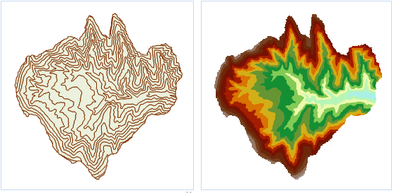 |
| Figure: Isosurface Vector to Raster Result. |