


Instructions for use
When a part of the existing Raster Data is needed as the research range and the Spatial Range of the original Raster Data is desired to be maintained, the grid can be cut.
The DEM cut function cuts the Raster Dataset according to a given 2D line (called the "cut line"), resulting in two new Raster Datasets, one to the left and one to the right of the cut line. The cutting line may be a straight line, a polyline, a polygon, or the like. Left and right refer to the left and right sides of the direction of the nodal sequence of the cut line. Whether those cells through which the cut line passes are assigned to the left or to the right, that is, if the center point of a cell lies to the left (or to the right) of the split line, the cell is assigned to that side.
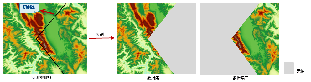 |
| Figure: Schematic diagram of "DEM cutting" |
Operating instructions
- Spatial Analysis tab-> Raster Analysis group-> Surface Analysis-> DEM Cut item, draw a cut line on the map, and click the right mouse button to bring up the DEM Cut dialog.
- Set the data for which the cutting operation is required. Select the Source Dataset to be cut and the Datasource where it is located.
- Set the cutting Result Data. Select the Target Datasource where the Result Dataset is to be saved, and name Result Dataset 1 and Result Dataset 2.
- After the above Parameter Settings are completed, click the "OK" button to execute the DEM cutting operation; click the "Cancel" button to exit the current operation.
Remark
DEM Clipping is different from Raster Map Clipping. The Spatial Range of the two Result Datasets obtained by DEM Clipping is consistent with the Spatial Range of the original Raster Data, and the part without data is assigned with "no value". The result of the raster Map Clipping is a Dataset, and the Spatial Range is the range of the clipped area, which is smaller than range of the original data.
 Related topics