Map Grid
Instructions for use
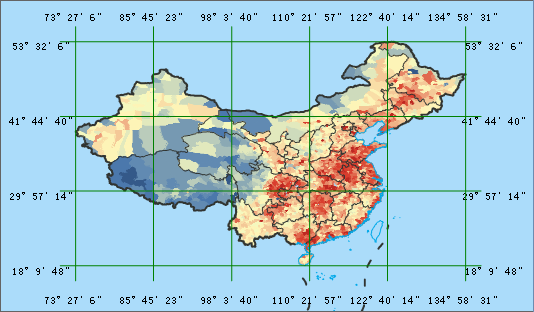
Map Grid can divide the mapping area into grids according to plane coordinates or longitude and latitude lines, and describe or express the attribute classification, statistical classification and change parameters in the grid as a unit, that is, to express the dynamic space-time change law on the map.
Map Grid includes Graticules and Measured Grids. When the Map Coordinate System is a Geographic Coordinate System or a Projected Coordinate System, the grid type can be set as a longitude-latitude grid or a kilometer grid; When the Map Coordinate System is Planar Coordinate System, the grid type can only be set to kilometer grid.
Function entrance
- Data tab-> Data Processing-> Map Cartography-> Map Grid.
- Map tab-> Drawing-> Map Grid.
- Toolbox-> Map Cartography-> Map Grid.
Parameter Description
- Parameter Settings:
- Grid type: supports two types: Graticules and Measured Grids. If it is a Geographic Coordinate System, only the longitude and latitude network can be selected; if it is a Planar Coordinate System, only the kilometer network can be selected; if it is a Projected Coordinate System, any one can be selected.
- Setting mode: Support Custom Bounds, Uses Specified Dataset Bounds, Current Map Window Extent, There are four ways to Current Range of Map Bookmark. Select Custom Bounds to activate the Bounds Info setting below and select Uses Specified Dataset Bounds to activate the Extent Data setting below; If Current Map Window Extent is selected, Bounds Info and Extent Data below cannot be set; Selecting Map Bookmark Range requires that there must be map bookmarks in Current Map, and with this setting selected, the Bookmark Range option in Extent Data is activated.
- Grid shape: The generated grid shape, which supports two types of quadrilateral and hexagon.
- Extent Data: Specify the Dataset and Datasource on which the Map Grid generates the range, or the bookmark range.
- Bounds Info: Set the starting longitude and latitude for generating Map Grid.
- Grid Info: When the grid shape is quadrilateral, the Grid Info setting option is cell width/height; when the grid shape is hexagonal, it is cell side length.
- Cell Width: Indicates the width of each quadrilateral cell in the grid.
- Cell Height: Indicates the height of each quadrilateral cell in the grid.
- Cell Side Length: Indicates the side length of each hexagonal cell in the mesh. It is activated when the mesh shape is set to hexagonal.
- Number of Columns/Number of Rows: indicates the number of rows and columns in the cells used to generate the grid. The default value is 6 columns and 4 rows. Set the number of rows and columns to automatically calculate and generate cell width/height or cell side length parameters.
- Result Settings:
- Smoothness: default is 2 range 1,5. If Smoothness is 1, Smooth Line will not be performed. If no insertion point is used, there are only two endpoints of the cell.
- Dataset Type: Data Type of Map Grid result output, supporting Point Dataset, Line Dataset, Region Dataset and CAD Dataset.
- Datasource/Dataset: Set the Resulting dataset name and the Datasource.
- Label Grid check box: Select to display the label at Primary and click the AaBb button to set text-related attributes on the Text Style Settings dialog.
- Show Major Division check box: If checked, a division line will be displayed at the intersection of each crisscross grid line and the map outline; otherwise, it will not be displayed.
- Click the Run button to execute the Map Grid function.


