Connecting Water System
 Introduction
To connect water system is based on the grid water system and flow direction. It assigns each river in the water system a unique value.
The water system connection records the node connection information. The red point below is the intersection point between two river segments. A river segment connects two intersection points, or an intersection point and a pour point, or an intersection point and a watershed.
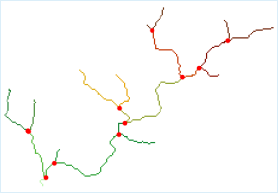 |
| Figure: Water System Connection |
In the result of water system, the river segments should be greater than or equal to 1.
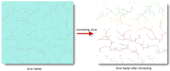 |
| Figure: Result of Water System Connection |
Functional Entrances
- Click Spatial Analysis > Raster Analysis > Hydrology Analysis. In the Workflow Manager window select Connect Water System. (SuperMap iDesktop)
- Click Spatial Analysis > Raster Analysis > Hydrology Analysis drop-down button and select Connect Water System. (SuperMap iDesktopX)
- Toolbox > Raster Analysis > Hydrology Analysis > Connect Water System. (SuperMap iDesktopX)
Parameter Description
- Water System Data: Select the datasource and dataset of the grid water system.
- Flow Direction Data: Select the datasource and dataset of the flow direction. See Calculate Flow Direction.
- Result Data: The result names of datasource and dataset.
- Click Ready to finalize the preparation of parameters. And so, you can execute the operation anytime. If you click Cancel Ready, you can continue setting parameters.
Note: Click the Ready dropdown button, the Cancel All button appears, it is used to cancel the ready status of all the steps.
- Click Execute. The output window will tell you if it is successful or not.