


Data Export
Feature Description
The Data Export function is used to export data from SuperMap ImageX Pro to common formats, enabling data sharing and collaboration.
For supported export formats, please refer to the Supported Formats for Data Import and Export page.
Feature Entry
- Start tab -> Data Processing group -> Data Export.
- Workspace Manager -> Dataset or data source context menu -> Export Dataset.
Steps
- Click the Start tab -> Data Processing group -> Data Export button to open the Data Export dialog.
- Click the Add button on the toolbar or double-click the Dataset column cell in the list box. The Select dialog displays all data sources in the current workspace on the left and all dataset names and types within the selected data source on the right. Select one or more datasets and click OK to add them to the export list.
- All added data appears in the list box on the left of the Data Export dialog. Use the toolbar above to add, remove datasets, or modify export properties uniformly. The list box includes:
- Dataset: Displays the name of the dataset to export.
- Export Type: Automatically identifies the format based on dataset type. Click the drop-down button under Export Type to select other formats.
- Result File: The exported file name, defaulting to the dataset name. Double-click the column or press F2 to rename: select the dataset, click Result File or press F2, then enter a new name.
- Export Path: Shows the default export path. Double-click Export Path for a selected dataset to change it in the Browse Folder window. Note: Non-existent paths are created automatically.
- Overwrite: Check this box to overwrite existing files with the same name; uncheck to skip exporting.
- Status: Displays Unconverted before export, Succeed on success, or Failed on failure.
- Select one or more files in the list box to configure parameters in the Data Export dialog's right panel. Parameters vary by export format:
- Export Vector Data (e.g., SHP, CSV, DWG, Excel):
- Export Point As WKT: Available only for CSV export. Determines whether to export points as WKT fields.
- Export Header: Available only for CSV export. Controls exporting header information.
- Export Extended Field: Available only for AutoCAD files. Controls exporting extended fields.
- Export Extension Records: Available only for AutoCAD files. Controls exporting extension records.
- Export Borders: Available only for AutoCAD files. Controls exporting border data.
- Export Line Width: Available only for AutoCAD files. Controls exporting polyline width data.
- Object Color by Layer: Available only for AutoCAD files. When checked, all objects adopt the layer's color; if unchecked, objects retain their current color settings.
- CAD Version: Available only for AutoCAD files. Select the DWG/DXF version (AutoCAD R12, R13, R14, 2000, 2004, 2007; default is 2013).
- Style Mapping File: Available only for AutoCAD files. Option to export a style mapping file.
- Charset: Character encoding type for exported datasets. Default is ASCII; options include UTF-8 for Chinese characters and Unicode for cross-platform support. See Charset List.
- Filter Expression: Filters objects using SQL expressions. Refer to SQL Expression.
- Export China Standard Vector Exchange Format:
- VCT Version: Select from CNSDTF_VCT 1.0, LandUse_VCT 2.0, or LandUse_VCT 3.0.
- VCT Layer: Configure VCT layers via Config File (import existing) or Custom (manual settings).
- Charset: Character encoding type. See Charset List.
- Export Telecom Files:
- Dataset List: Select datasets by type (point, line, polygon); multiple selections allowed.
- Field: Available only for Telecom Vector Text export.
- Charset: Character encoding type. See Charset List.
- Filter Expression: Filters objects using SQL expressions. Refer to SQL Expression.
- Export File GeoDatabase Vector File (FileGDB):
- Dataset List: Select datasets to export (multiple allowed).
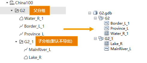
- For grouped datasets: FileGDB does not support subgroups; only parent group datasets are listed by default.
- To export subgroups: Use Add to include subgroup datasets. Exported subgroups lose hierarchy and become parallel to parent groups.
- Append: Append data to an existing FileGDB file; requires setting connection fields.
- Charset: Character encoding type. See Charset List.
- Retain Grouping: Check to preserve dataset groups in FileGDB; uncheck to discard.
 Notes:
To ensure complete export, datasets in groups must meet:
- Only 2D/3D point, line, or region datasets are supported; tabular datasets are excluded.
- All datasets in a group must share the same coordinate system; mismatches export only datasets matching the first dataset's system.
- Groups must be single-level (no nested subgroups).
- Preserve 64-bit Integer Field Format: Check to retain 64-bit integer fields (requires ArcGIS Pro 3.2+); uncheck to convert to double precision.
- Filter Expression: Filters objects using SQL expressions. Refer to SQL Expression.
- Dataset List: Select datasets to export (multiple allowed).
- Export PersonalGDB Vector File:
- Dataset List: Select datasets to export (multiple allowed).
- Filter Expression: Filters objects using SQL expressions. Refer to SQL Expression.
- Export GJB File:
- Dataset List: Select datasets to export (multiple allowed).
- Charset: Character encoding type. See Charset List.
- Export Layer Type: Options include Measurement Control Point, Industrial and Agricultural Social and Cultural Facilities, Residential Area and Ancillary Facilities, Land Transportation, Pipeline, Water/Land, Submarine Geomorphology and Geology, Reefs/Shipwrecks/Obstacles; default is Measurement Control Point.
- Filter Expression: Filters objects using SQL expressions. Refer to SQL Expression.
- Export to Raster or Image Dataset:
- Compression Method: For TIFF files, select from None, LZW, JPEG, or DEFLATE.
- None: No compression.
- LZW: Lossless compression using advanced string table algorithms.
- JPEG: Lossy compression based on DCT; supports 8-bit integer data (single or multi-band) and 16-bit data's first 12 bits.
- DEFLATE: Lossless compression combining LZ77 and Huffman coding.
- Compression Ratio (%): Set image compression ratio (default 75%). Available only for JPG files.
- Coordinate Reference File: Click Select to set the path for raster dataset coordinate references. Available only for JPG, PNG, BMP, and GIF formats.
- Export Affine Information to TFW File: Check to export affine transformation data to an external TFW file; uncheck to embed in TIFF files. Enabled only for TIFF format.
Notes:- For JPG exports, width or height must not exceed 65,500 pixels. PNG exports have no such limit.
- Compression Method: For TIFF files, select from None, LZW, JPEG, or DEFLATE.
- Export Vector Data (e.g., SHP, CSV, DWG, Excel):
- Check Auto-Close Dialog After Export to close the dialog upon completion (default checked).
- Click Export to batch export all datasets. The Export Progress window shows overall and individual export status.
Notes:- If all data sources use the image data engine, the export button is disabled (grayed out).
- If image data engines exist, they appear in the Select dialog but their datasets cannot be added.
- Exporting KML/KMZ requires datasets to use WGS_1984 geographic coordinate system; otherwise, export fails.
- VCT exports require layer type configuration; otherwise, export fails.
- For telecom raster data:
- Only Grid-type datasets are supported.
- Only 16-bit raster data can be exported; lower bit depths are auto-converted to 16-bit.
- Exporting attribute tables to Excel supports up to 100,000 records; datasets with zero records fail.
- The third-party TIF library supports exports up to 4GB. For larger data, split into blocks or export as SIT Image File (deprecated).
- SHP exports are limited to 4GB; use FileGDB for larger data.
- SHP field names are truncated to 10 bytes (not characters). For example, "Population2025" becomes "Population", and "行政区名称" becomes "行政区" (UTF-8). Duplicate names are appended with suffixes (e.g., "Populati_1"). Shorten field names before export.
Related Topics
Supported Formats for Data Import and Export